IMAGES TAKEN NEAR TO
Park Ridings, LONDON, N8 0LB
Introduction
This page details the photographs taken nearby to Park Ridings, N8 0LB by members of the Geograph project.
The Geograph project started in 2005 with the aim of publishing, organising and preserving representative images for every square kilometre of Great Britain, Ireland and the Isle of Man.

There are currently over 7.5m images from over14,400 individuals and you can help contribute to the project by visiting https://www.geograph.org.uk
Image Map (Loading...)


Getting Data...Please wait
Leaflet Map data © OpenStreetMap
Images are licensed for reuse under creativecommons.org/licenses/by-sa/2.0
Notes
- Clicking on the map will re-center to the selected point.
- The higher the marker number, the further away the image location is from the centre of the postcode.
Image Listing (125 Images Found)
Images are licensed for reuse under creativecommons.org/licenses/by-sa/2.0
Image
Details
Distance
1
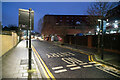
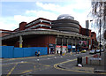
Loading bay of Wood Green Shopping City off Mayes Road
Image: © Tom Page
Taken: 20 Dec 2021
0.07 miles
2
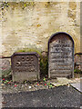
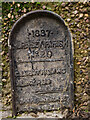
Hornsey Parish boundary marker no. 19 (1887)
Image: © Jim Osley
Taken: 17 Nov 2020
0.08 miles
3
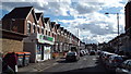
Alexandra Road, Wood Green
Alexandra Road is a residential street in Wood Green, North London.
Image: © Malc McDonald
Taken: 22 Mar 2014
0.08 miles
4

Wood Green : Wood Green Shopping Centre
View from Mayes Road.
Image: © Jim Osley
Taken: 6 Jan 2021
0.09 miles
5

Marketplace entrance to the Wood Green Shopping City on Mayes Road
Image: © Tom Page
Taken: 20 Dec 2021
0.10 miles
6

Entrance to market hall, Wood Green Shopping Centre
The market hall is an indoor market within the Wood Green Shopping City built in the 1970s.
Image: © Jim Osley
Taken: 30 May 2011
0.10 miles
8

Mixed messages, Wood Green
Cheap parking offered at Wood Green Shopping City, so where does that leave the green agenda promoted on the poster to the right?!
Image: © Jim Osley
Taken: 21 Apr 2013
0.10 miles
10
Hornsey Parish boundary marker no. 20 (1887)
Located in Arnold Bennett Way.
Image: © Jim Osley
Taken: 18 Nov 2020
0.10 miles