IMAGES TAKEN NEAR TO
Malvern Road, LONDON, N8 0LA
Introduction
This page details the photographs taken nearby to Malvern Road, N8 0LA by members of the Geograph project.
The Geograph project started in 2005 with the aim of publishing, organising and preserving representative images for every square kilometre of Great Britain, Ireland and the Isle of Man.

There are currently over 7.5m images from over14,400 individuals and you can help contribute to the project by visiting https://www.geograph.org.uk
Image Map
Images are licensed for reuse under creativecommons.org/licenses/by-sa/2.0
Notes
- Clicking on the map will re-center to the selected point.
- The higher the marker number, the further away the image location is from the centre of the postcode.
Image Listing (152 Images Found)
Images are licensed for reuse under creativecommons.org/licenses/by-sa/2.0
Image
Details
Distance
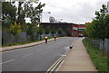
1
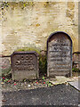
Hornsey Parish boundary marker no. 19 (1887)
Image: © Jim Osley
Taken: 17 Nov 2020
0.08 miles
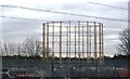
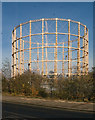
2
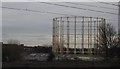
Gasholder between Wood Green and Hornsey
Image: © N Chadwick
Taken: 25 Feb 2011
0.10 miles
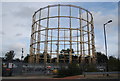
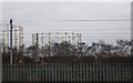
9
De-commissioned gasholder, Wood Green
Originally one of a pair.
Image: © Jim Osley
Taken: 5 Dec 2016
0.11 miles
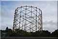
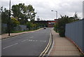
10
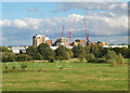
Wood Green : Clarendon
Extensive brownfield development on the site of former gasworks.
Image: © Jim Osley
Taken: 2 Oct 2021
0.11 miles