IMAGES TAKEN NEAR TO
Seymour Road, LONDON, N8 0BE
Introduction
This page details the photographs taken nearby to Seymour Road, N8 0BE by members of the Geograph project.
The Geograph project started in 2005 with the aim of publishing, organising and preserving representative images for every square kilometre of Great Britain, Ireland and the Isle of Man.

There are currently over 7.5m images from over14,400 individuals and you can help contribute to the project by visiting https://www.geograph.org.uk
Image Map
Images are licensed for reuse under creativecommons.org/licenses/by-sa/2.0
Notes
- Clicking on the map will re-center to the selected point.
- The higher the marker number, the further away the image location is from the centre of the postcode.
Image Listing (204 Images Found)
Images are licensed for reuse under creativecommons.org/licenses/by-sa/2.0
Image
Details
Distance
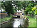
1
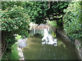
The New River south of Seymour Road, N8
Image: © Mike Quinn
Taken: 18 Jun 2015
0.01 miles
2

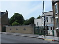
Bridge over the New River, Seymour Road, N8
See Image Photo shows the south side of the road; the bridge is marked by the fence (not the concrete wall). The New River emerges here from a 200 yard long tunnel, running NW - SE, that starts just to the west of Wightman Road and passes under Allison Road and Hewitt Road to the north.
Image: © Mike Quinn
Taken: 18 Jun 2015
0.02 miles
3
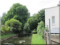
The New River north of Warham Road, N4
Image: © Mike Quinn
Taken: 18 Jun 2015
0.02 miles
4
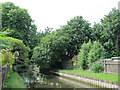
The New River north of Warham Road, N4 (2)
Image: © Mike Quinn
Taken: 18 Jun 2015
0.02 miles
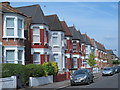
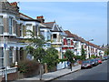
5
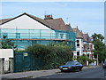
Seymour Road, N8 (2)
See Image Photo shows the north side of the road, where it crosses over the New River, which is in a tunnel - see Image The course of the aqueduct is at 45 degrees to the line of the road: it's not obvious, but the gable end of the first house on the left is also at 45 degrees to the road.
Image: © Mike Quinn
Taken: 18 Jun 2015
0.02 miles
6
Bridge over the New River, Warham Road, N4 (2)
See Image The New River crosses the road at around 45 degrees, and a house has been built in the resulting triangle east of the aqueduct on the north side of the road.
Image: © Mike Quinn
Taken: 18 Jun 2015
0.04 miles
8
The New River north of Pemberton Road, N4
Image: © Mike Quinn
Taken: 18 Jun 2015
0.05 miles
9
Hewitt Road, N8 (3)
Image: © Mike Quinn
Taken: 18 Jun 2015
0.06 miles
10
Warham Road, N4 (3)
The north side, east of the New River - see Image
Image: © Mike Quinn
Taken: 18 Jun 2015
0.07 miles