IMAGES TAKEN NEAR TO
Manger Road, LONDON, N7 9TQ
Introduction
This page details the photographs taken nearby to Manger Road, N7 9TQ by members of the Geograph project.
The Geograph project started in 2005 with the aim of publishing, organising and preserving representative images for every square kilometre of Great Britain, Ireland and the Isle of Man.

There are currently over 7.5m images from over14,400 individuals and you can help contribute to the project by visiting https://www.geograph.org.uk
Image Map
Images are licensed for reuse under creativecommons.org/licenses/by-sa/2.0
Notes
- Clicking on the map will re-center to the selected point.
- The higher the marker number, the further away the image location is from the centre of the postcode.
Image Listing (121 Images Found)
Images are licensed for reuse under creativecommons.org/licenses/by-sa/2.0
Image
Details
Distance
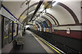
5
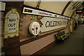
Caledonian Road underground station: signage on the northbound platform
Image: © Christopher Hilton
Taken: 30 Sep 2013
0.08 miles
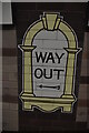
6
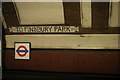
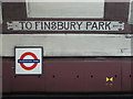
Caledonian Road underground station: platform-level signage
At the time that this stretch of the Piccadilly Line was built, as one of the early deep-level tubes, a visual and conceptual grammar of signage was still being worked out by the companies involved. Caledonian Road enshrines an experiment that did not catch on, signs pointing towards the then-termini to indicate which direction a particular platform's trains would be going.
Image: © Christopher Hilton
Taken: 30 Sep 2013
0.08 miles
7
Caledonian Road underground station: platform-level signage
At the time that this stretch of the Piccadilly Line was built, as one of the early deep-level tubes, a visual and conceptual grammar of signage was still being worked out by the companies involved. Caledonian Road enshrines an experiment that did not catch on, signs pointing towards the then-termini to indicate which direction a particular platform's trains would be going.
Image: © Christopher Hilton
Taken: 30 Sep 2013
0.08 miles
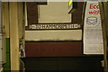
8
Piccadilly line train, Caledonian Road Station
Image: © N Chadwick
Taken: 5 Jan 2020
0.08 miles
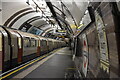
9
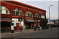
Caledonian Road underground station
The large semi-circular arches and oxblood tiles are typical of the stations designed by Leslie Green in the early years of the 20th century. (For links to other Green-designed stations, see Image)
Notice, on the lamp-post, a sign from the London Borough of Islington announcing its new policy of a borough-wide default speed limit of 20 miles per hour rather than the usual 30 mph.
Image: © Christopher Hilton
Taken: 30 Sep 2013
0.08 miles
10
Caledonian Road tube station, Caledonian Road, N7 - detail
See Image
Image: © Mike Quinn
Taken: 18 Jan 2017
0.08 miles