IMAGES TAKEN NEAR TO
Fleece Walk, LONDON, N7 9TE
Introduction
This page details the photographs taken nearby to Fleece Walk, N7 9TE by members of the Geograph project.
The Geograph project started in 2005 with the aim of publishing, organising and preserving representative images for every square kilometre of Great Britain, Ireland and the Isle of Man.

There are currently over 7.5m images from over14,400 individuals and you can help contribute to the project by visiting https://www.geograph.org.uk
Image Map
Images are licensed for reuse under creativecommons.org/licenses/by-sa/2.0
Notes
- Clicking on the map will re-center to the selected point.
- The higher the marker number, the further away the image location is from the centre of the postcode.
Image Listing (105 Images Found)
Images are licensed for reuse under creativecommons.org/licenses/by-sa/2.0
Image
Details
Distance
1
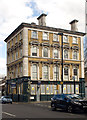
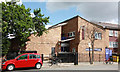
Former public house, North Road, Holloway
Grade II listed former public house, ("The Lamb Tavern") built in 1855 to the designs of James Bunstone Bunning. One of four such establishments built to serve the needs of the nearby Caledonian livestock market. Detailed architectural description at this https://www.historicengland.org.uk/listing/the-list/list-entry/1208151. An earlier view at Image
Image: © Jim Osley
Taken: 17 Apr 2016
0.03 miles
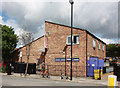
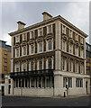
4
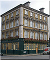
The Lamb Public House, North Road, Islington
One of four Italianate gin palaces built to serve the Caledonian Cattle Market. This one is at the corner of North Road and Shearling Way, and is currently unoccupied.
Image: © Jim Osley
Taken: 23 Feb 2009
0.09 miles
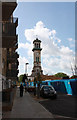
8
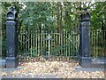
The original railings of the Metropolitan Cattle Market
The Metropolitan Cattle Market opened in 1855 to replace Smithfield as London's main livestock market. Prior to that, it was known as Copenhagen Fields. On 21st April 1834, 100,000 people gathered here in support of the Tolpuddle martyrs. The cattle market closed in 1939. The original railings of the cattle market can still be seen here. The sale of meat ended in the 1960s. The market buildings were then mostly demolished, council housing, principally the Market Estate, was built over much of the site, and the remainder converted to Caledonian Park with its imposing clock tower - see https://www.geograph.org.uk/photo/7015823
A very full and interesting history can be seen at https://alondoninheritance.com/london-monuments/caledonian-park-history-murals-and-a-fire/
Image: © Marathon
Taken: 9 Nov 2021
0.11 miles
10
Former public house, Holloway
Built as a gin palace to serve nearby Caledonian Market, now converted into office and residential accommodation. See also Image]
Image: © Jim Osley
Taken: 1 Dec 2012
0.12 miles