IMAGES TAKEN NEAR TO
York Way, LONDON, N7 9QL
Introduction
This page details the photographs taken nearby to York Way, N7 9QL by members of the Geograph project.
The Geograph project started in 2005 with the aim of publishing, organising and preserving representative images for every square kilometre of Great Britain, Ireland and the Isle of Man.

There are currently over 7.5m images from over14,400 individuals and you can help contribute to the project by visiting https://www.geograph.org.uk
Image Map
Images are licensed for reuse under creativecommons.org/licenses/by-sa/2.0
Notes
- Clicking on the map will re-center to the selected point.
- The higher the marker number, the further away the image location is from the centre of the postcode.
Image Listing (67 Images Found)
Images are licensed for reuse under creativecommons.org/licenses/by-sa/2.0
Image
Details
Distance
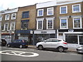
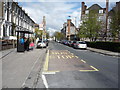
1
Camden Park Road at the junction of York Road
Image: © David Howard
Taken: 28 Aug 2014
0.01 miles
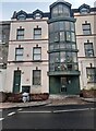
3
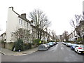
St. Augustine's Road, near Camden Town
St. Augustine's Road is a residential road in the inner suburbs of north London.
Image: © Malc McDonald
Taken: 26 Jan 2019
0.04 miles
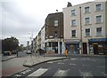
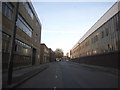
6

York Way, near Holloway
York Way in inner north London.
Image: © Malc McDonald
Taken: 26 Jan 2019
0.07 miles
8

Ordnance Survey Cut Mark
This OS cut mark can be found on a post at entrance to Market Road Pitches. It marks a point 46.056m above mean sea level.
Image: © Adrian Dust
Taken: 1 Aug 2016
0.11 miles
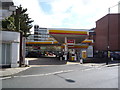
9
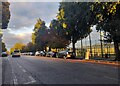
Market Road, Islington
Islington Tennis Centre is on the right.
Image: © David Howard
Taken: 20 Oct 2022
0.11 miles