IMAGES TAKEN NEAR TO
Brewery Road, LONDON, N7 9NH
Introduction
This page details the photographs taken nearby to Brewery Road, N7 9NH by members of the Geograph project.
The Geograph project started in 2005 with the aim of publishing, organising and preserving representative images for every square kilometre of Great Britain, Ireland and the Isle of Man.

There are currently over 7.5m images from over14,400 individuals and you can help contribute to the project by visiting https://www.geograph.org.uk
Image Map
Images are licensed for reuse under creativecommons.org/licenses/by-sa/2.0
Notes
- Clicking on the map will re-center to the selected point.
- The higher the marker number, the further away the image location is from the centre of the postcode.
Image Listing (123 Images Found)
Images are licensed for reuse under creativecommons.org/licenses/by-sa/2.0
Image
Details
Distance
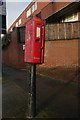
1
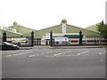
Islington Tennis Centre
Islington Tennis Centre is situated to the north west of the London Borough of Islington and is one of the busiest tennis centres in the country. It has six indoor and two outdoor courts http://www.better.org.uk/leisure/islingtontc#/
Image: © Paul Gillett
Taken: 6 Sep 2014
0.06 miles
2
Caledonian Road Methodist Church
On the corner of Caledonian Road and Market Way
Image: © Danny P Robinson
Taken: 21 Apr 2007
0.07 miles
5
Islington Tennis Centre
Islington Tennis Centre is situated to the north west of the London Borough of Islington and is one of the busiest tennis centres in the country. It has six indoor and two outdoor courts http://www.better.org.uk/leisure/islingtontc#/
Image: © Paul Gillett
Taken: 6 Sep 2014
0.07 miles
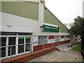
7
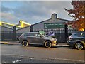
Islington Tennis Centre on Market Road
Image: © David Howard
Taken: 20 Oct 2022
0.07 miles
8
Former pub on Market Road, near Holloway
This building was once the White Horse pub. It has now been converted for residential use. The White Horse was one of four pubs serving the neighbouring cattle market, which has long since closed. More information about the pubs and the market they served is here: https://pubology.wordpress.com/2008/08/21/metropolitan-cattle-market-pubs/
Image: © Malc McDonald
Taken: 26 Jan 2019
0.08 miles
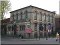
9
Former pub near Caledonian Park
There were once four impressive pubs on the corners of what was the Metropolitan Cattle Market and is now Caledonian Park. The north-east, north-west and south-east ones survive but none of them are now pubs. The three surviving buildings were the White Horse, The Lamb, and The Lion. This was the south-east one on the corner of Market Road.
See https://www.geograph.org.uk/photo/7015823 and https://alondoninheritance.com/london-monuments/caledonian-park-history-murals-and-a-fire/
Image: © Marathon
Taken: 9 Nov 2021
0.08 miles