IMAGES TAKEN NEAR TO
Hungerford Road, LONDON, N7 9LX
Introduction
This page details the photographs taken nearby to Hungerford Road, N7 9LX by members of the Geograph project.
The Geograph project started in 2005 with the aim of publishing, organising and preserving representative images for every square kilometre of Great Britain, Ireland and the Isle of Man.

There are currently over 7.5m images from over14,400 individuals and you can help contribute to the project by visiting https://www.geograph.org.uk
Image Map
Images are licensed for reuse under creativecommons.org/licenses/by-sa/2.0
Notes
- Clicking on the map will re-center to the selected point.
- The higher the marker number, the further away the image location is from the centre of the postcode.
Image Listing (70 Images Found)
Images are licensed for reuse under creativecommons.org/licenses/by-sa/2.0
Image
Details
Distance
1
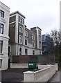
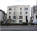
Cambridge House, Camden Road Collegiate School
This former school building is on Camden Road. It has been converted into apartments.
Image: © David Anstiss
Taken: 10 Mar 2013
0.06 miles
4
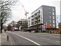
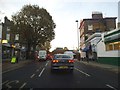
Camden Road, Holloway
Camden Road forms part of the A503. This view looks southwards, heading away from Holloway towards Camden Town.
Image: © Malc McDonald
Taken: 26 Jan 2019
0.08 miles
6
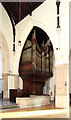
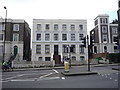
St. Luke’s Church, Hillmarton Road, Benchmark
Image: © Cipollini
Taken: 5 Sep 2024
0.08 miles