IMAGES TAKEN NEAR TO
Hungerford Road, LONDON, N7 9LB
Introduction
This page details the photographs taken nearby to Hungerford Road, N7 9LB by members of the Geograph project.
The Geograph project started in 2005 with the aim of publishing, organising and preserving representative images for every square kilometre of Great Britain, Ireland and the Isle of Man.

There are currently over 7.5m images from over14,400 individuals and you can help contribute to the project by visiting https://www.geograph.org.uk
Image Map
Images are licensed for reuse under creativecommons.org/licenses/by-sa/2.0
Notes
- Clicking on the map will re-center to the selected point.
- The higher the marker number, the further away the image location is from the centre of the postcode.
Image Listing (71 Images Found)
Images are licensed for reuse under creativecommons.org/licenses/by-sa/2.0
Image
Details
Distance
1
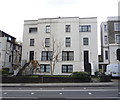
Former Camden Road Collegiate School
Image: © Christopher Hilton
Taken: 19 Jan 2017
0.10 miles
2
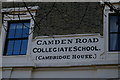
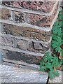
Inscription on former Camden Road Collegiate School
Image: © Christopher Hilton
Taken: 19 Jan 2017
0.10 miles
4
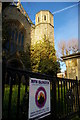
Mountain of Fire and Miracles church, Camden Road
Mountain of Fire and Miracles is an international Pentecostalist church with numerous branches in the United Kingdom: here the Islington church occupies the former Camden Baptist Church.
Image: © Christopher Hilton
Taken: 19 Jan 2017
0.11 miles
6
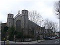
Camden Road Baptist Church
Former Grade II listed Baptist Church and church hall, now hostel (was converted in 1990). It is on the junction of Camden Road and Hilldrop Road (on the right).
See http://www.britishlistedbuildings.co.uk/en-369013-1-and-2-hilldrop-road-greater-london-aut for more details on the church.
Image: © David Anstiss
Taken: 10 Mar 2013
0.12 miles
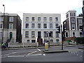
7
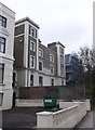
Cambridge House, Camden Road Collegiate School
This former school building is on Camden Road. It has been converted into apartments.
Image: © David Anstiss
Taken: 10 Mar 2013
0.12 miles
9
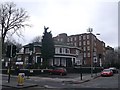
The Copenhagen Pub, Camden
Public house on the junction of Camden Road and Dalmeny Avenue.
In the background is Ada Lewis House (block of apartments).
Strangely named because Image is about a mile away! Unless another local reason.
Image: © David Anstiss
Taken: 10 Mar 2013
0.12 miles
10
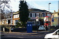
Former pub, corner of Dalmeny Avenue
By 2018 this interwar pub had been demolished. At the time, as can be seen, it was occupied by The Kindness Offensive, a campaign to improve life in the city by perpetrating random acts of kindness.
Image: © Christopher Hilton
Taken: 19 Jan 2017
0.13 miles