IMAGES TAKEN NEAR TO
Sterling Way, LONDON, N7 9HU
Introduction
This page details the photographs taken nearby to Sterling Way, N7 9HU by members of the Geograph project.
The Geograph project started in 2005 with the aim of publishing, organising and preserving representative images for every square kilometre of Great Britain, Ireland and the Isle of Man.

There are currently over 7.5m images from over14,400 individuals and you can help contribute to the project by visiting https://www.geograph.org.uk
Image Map
Images are licensed for reuse under creativecommons.org/licenses/by-sa/2.0
Notes
- Clicking on the map will re-center to the selected point.
- The higher the marker number, the further away the image location is from the centre of the postcode.
Image Listing (154 Images Found)
Images are licensed for reuse under creativecommons.org/licenses/by-sa/2.0
Image
Details
Distance
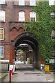
1
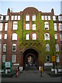
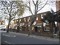
Entrance to Caledonian Estate, Caledonian Road
The block at the front is Carrick House and through the arches are the blocks behind. This is an estate owned and managed by Islington Council. 2 of the 4 signs at the front are "No Parking" signs.
Image: © Danny P Robinson
Taken: 21 Apr 2007
0.02 miles
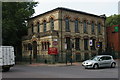
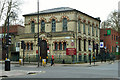
3
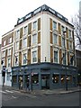
The Cally, Islington
Originally known as the Balmoral Castle.
Image: © Chris Whippet
Taken: 15 Mar 2015
0.02 miles
4
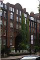
Garrick House, Caledonian Road
Part of the London Borough of Islington's Caledonian Estate.
Notice, on the lamp-post, a sign from the London Borough of Islington announcing its new policy of a borough-wide default speed limit of 20 miles per hour rather than the usual 30 mph.
Image: © Christopher Hilton
Taken: 30 Sep 2013
0.03 miles
5
Garrick House, Caledonian Road
Part of the London Borough of Islington's Caledonian Estate, more of which can be seen through the arch.
Image: © Christopher Hilton
Taken: 30 Sep 2013
0.03 miles
6
Carrick House
Grade II listed. https://historicengland.org.uk/listing/the-list/list-entry/1280795
Image: © N Chadwick
Taken: 5 Jan 2020
0.03 miles
7
Caledonian Road Methodist Church
Image: © Christopher Hilton
Taken: 30 Sep 2013
0.04 miles
8
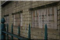
Foundation stones, Caledonian Road Methodist Church
The street frontage of the church has six foundation stones in all, three on either side of the door.
Image: © Christopher Hilton
Taken: 30 Sep 2013
0.04 miles
10
Caledonian Road Methodist Church
A grade II listed building, built in 1870 as a Primitive Methodist chapel.
Image: © Robin Webster
Taken: 5 Feb 2011
0.04 miles