IMAGES TAKEN NEAR TO
Vale Royal, LONDON, N7 9AU
Introduction
This page details the photographs taken nearby to Vale Royal, N7 9AU by members of the Geograph project.
The Geograph project started in 2005 with the aim of publishing, organising and preserving representative images for every square kilometre of Great Britain, Ireland and the Isle of Man.

There are currently over 7.5m images from over14,400 individuals and you can help contribute to the project by visiting https://www.geograph.org.uk
Image Map
Images are licensed for reuse under creativecommons.org/licenses/by-sa/2.0
Notes
- Clicking on the map will re-center to the selected point.
- The higher the marker number, the further away the image location is from the centre of the postcode.
Image Listing (64 Images Found)
Images are licensed for reuse under creativecommons.org/licenses/by-sa/2.0
Image
Details
Distance
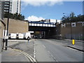
1
Emerging from the tunnel at York Way south junction
Image: © Roy Hughes
Taken: 16 Sep 2023
0.03 miles
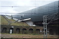
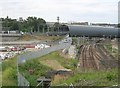
2

New buildings on York Way
Plus various other bits and pieces, seen from a Eurostar service. The gabled shed on the extreme left is Camden's Transport Services unit. The railway bridge on the right carries the North London Line across York Way. Beyond is the Mark Fitzpatrick Building.
Image: © Derek Harper
Taken: 20 Sep 2013
0.05 miles

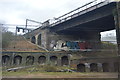
4
Railway bridge over York Way
Looking north.
Image: © JThomas
Taken: 23 Apr 2016
0.06 miles
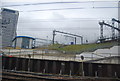
10
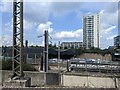
Railways north of Kings Cross
In the foreground, the East Coast Mainline out of Kings Cross emerges from Gasworks Tunnel, the first tunnel of its climb northwards. In the middle distance, the high-speed line from St Pancras International to the Channel Tunnel and beyond (HS1) crosses in a tube that forms the beginning of its long tunnel to Stratford International. Beyond, and still higher up, runs the North London Line, now part of London Overground, whose catenary is just visible in the top left of the picture. Beyond all this, the tower of the former Metropolitan Cattle Market.
Image: © Christopher Hilton
Taken: 25 Jun 2015
0.08 miles