IMAGES TAKEN NEAR TO
Centurion Close, LONDON, N7 8UG
Introduction
This page details the photographs taken nearby to Centurion Close, N7 8UG by members of the Geograph project.
The Geograph project started in 2005 with the aim of publishing, organising and preserving representative images for every square kilometre of Great Britain, Ireland and the Isle of Man.

There are currently over 7.5m images from over14,400 individuals and you can help contribute to the project by visiting https://www.geograph.org.uk
Image Map
Images are licensed for reuse under creativecommons.org/licenses/by-sa/2.0
Notes
- Clicking on the map will re-center to the selected point.
- The higher the marker number, the further away the image location is from the centre of the postcode.
Image Listing (162 Images Found)
Images are licensed for reuse under creativecommons.org/licenses/by-sa/2.0
Image
Details
Distance
1
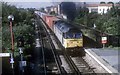
Container train passing Caledonian Road and Barnsbury
The morning Southampton to Ripple Lane, Barking container train is about to pass Caledonian Road and Barnsbury station. The driver has just opened the power controller; the result a nice exhaust of black smoke. Out of sight on the right behind the platform is Holloway prison.
Image: © roger geach
Taken: 13 Sep 1995
0.04 miles
3

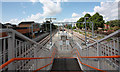
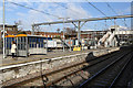
Caledonian Road & Barnsbury station on a wet November afternoon
The line through here was opened between 1850 and 1852 as the East & West India Docks & Birmingham Junction Railway. It was renamed the North London Railway in 1853. This gave a link from the Euston main line near Primrose Hill to the docks at Poplar via Bow. A station called Caledonian Road was opened in 1852 and existed until 1870 when Caledonian Road & Barnsbury station was opened as "Barnsbury" a little further east than the previous station. Barnsbury was renamed "Caledonian Road & Barnsbury" in 1893.
The line was electrified in 1916. All trains serving the station are now operated by London Overground, as well as frequent freight trains passing through. This view is from the eastbound platform looking in the direction of Camden Road. The line to the right is for freight.
Image: © Marathon
Taken: 26 Nov 2014
0.04 miles
6
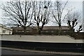
Caledonian Road & Barnsbury Station
Seen from the path leading to the station entrance on Offord Street.
Image: © Martin Addison
Taken: 5 Feb 2015
0.05 miles
8
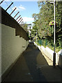
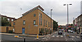
Caledonian Road and Barnsbury Station
The pedestrian ramp up from Caledonian Road. Considerable effort has been put into making this access attractive to passengers with fresh paint, new lighting and floral baskets.
Image: © Alan Murray-Rust
Taken: 22 Jul 2008
0.05 miles
9
A charter train coasts through Caledonian Road & Barnsbury station
The charter heading for Chingford is hauled by two Class 20/3 diesel locomotives numbers 20308 and 20312.
Image: © Roger Templeman
Taken: 26 Jan 2013
0.06 miles
10
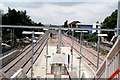
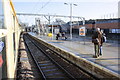
Caledonian Road & Barnsbury Station
Looking west from the footbridge, we see the island platform now used by all North London trains, the left side for westbound trains and the right side for eastbound trains. The track on the extreme left, which was formerly used by westbound passenger trains, is now used by freight trains only, and the platform alongside it is now just used for access.
Image: © Dr Neil Clifton
Taken: 30 Jun 2010
0.06 miles