IMAGES TAKEN NEAR TO
St. Clements Street, LONDON, N7 8BQ
Introduction
This page details the photographs taken nearby to St. Clements Street, N7 8BQ by members of the Geograph project.
The Geograph project started in 2005 with the aim of publishing, organising and preserving representative images for every square kilometre of Great Britain, Ireland and the Isle of Man.

There are currently over 7.5m images from over14,400 individuals and you can help contribute to the project by visiting https://www.geograph.org.uk
Image Map
Images are licensed for reuse under creativecommons.org/licenses/by-sa/2.0
Notes
- Clicking on the map will re-center to the selected point.
- The higher the marker number, the further away the image location is from the centre of the postcode.
Image Listing (125 Images Found)
Images are licensed for reuse under creativecommons.org/licenses/by-sa/2.0
Image
Details
Distance


6
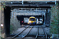
Between Bridges
London Overground Class 378 electric unit 378255 approaches Caledonian Road & Barnsbury station with a service to Richmond.
Image: © Martin Addison
Taken: 14 Dec 2017
0.06 miles
7
Zebra Crossing on Offord Road
The turn ahead is Westbourne Road.
Image: © DS Pugh
Taken: 5 Apr 2016
0.06 miles
9
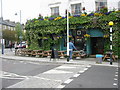
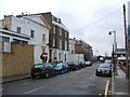
Hemingford Arms, Hemingford Road, London
Image: © Oast House Archive
Taken: 12 Apr 2005
0.06 miles
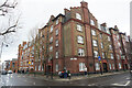
10
Westbourne Road, Barnsbury
Photographed from Arundel Square
Image: © Andrew Wilson
Taken: 16 Feb 2013
0.07 miles