IMAGES TAKEN NEAR TO
Westbourne Road, LONDON, N7 8AF
Introduction
This page details the photographs taken nearby to Westbourne Road, N7 8AF by members of the Geograph project.
The Geograph project started in 2005 with the aim of publishing, organising and preserving representative images for every square kilometre of Great Britain, Ireland and the Isle of Man.

There are currently over 7.5m images from over14,400 individuals and you can help contribute to the project by visiting https://www.geograph.org.uk
Image Map
Images are licensed for reuse under creativecommons.org/licenses/by-sa/2.0
Notes
- Clicking on the map will re-center to the selected point.
- The higher the marker number, the further away the image location is from the centre of the postcode.
Image Listing (111 Images Found)
Images are licensed for reuse under creativecommons.org/licenses/by-sa/2.0
Image
Details
Distance
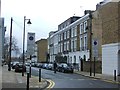
2
Zebra Crossing on Offord Road
The turn ahead is Westbourne Road.
Image: © DS Pugh
Taken: 5 Apr 2016
0.02 miles

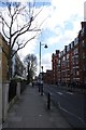
4
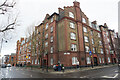
Arundel Square (south side)
Modern buildings, contrasting well with C19th terraces on the other three sides of the square.
Image: © Andrew Wilson
Taken: 16 Feb 2013
0.03 miles
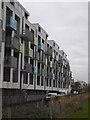
7
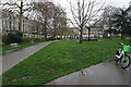
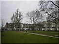
Turf zone ArundelSquare
Small park on Arundel Square, London.
Image: © Ian S
Taken: 24 Mar 2023
0.05 miles
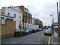
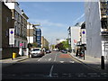
9
Westbourne Road, Barnsbury
Photographed from Arundel Square
Image: © Andrew Wilson
Taken: 16 Feb 2013
0.05 miles