IMAGES TAKEN NEAR TO
Queensland Road, LONDON, N7 7FG
Introduction
This page details the photographs taken nearby to Queensland Road, N7 7FG by members of the Geograph project.
The Geograph project started in 2005 with the aim of publishing, organising and preserving representative images for every square kilometre of Great Britain, Ireland and the Isle of Man.

There are currently over 7.5m images from over14,400 individuals and you can help contribute to the project by visiting https://www.geograph.org.uk
Image Map
Images are licensed for reuse under creativecommons.org/licenses/by-sa/2.0
Notes
- Clicking on the map will re-center to the selected point.
- The higher the marker number, the further away the image location is from the centre of the postcode.
Image Listing (279 Images Found)
Images are licensed for reuse under creativecommons.org/licenses/by-sa/2.0
Image
Details
Distance
1
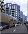
QN7 housing development, Queensland Road
Extensive housing development built to the designs of architects CZWG.
Image: © Jim Osley
Taken: 12 Aug 2014
0.02 miles
2

Queensland Terrace, Holloway, London N7
Apartment block adjacent to Arsenal's Emirates Stadium built to the designs of architects CZWG. More at this http://www.czwg.com/works/queensland-road.
Image: © Jim Osley
Taken: 19 Dec 2015
0.03 miles
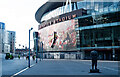
3
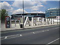
Highbury: Emirates Stadium, N5
Arsenal's name straddles the approach to the Emirates Stadium from Drayton Park.
Image: © Nigel Cox
Taken: 31 Jul 2007
0.04 miles
4

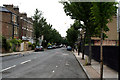
Queensland Road, London N7
A few years ago this road was full of various companies/local firms but now they have either been demolished or stand boarded up waiting for demolition. It has all changed because of the Emirates Stadium that was recently built and just out of sight on the left of this picture. Everything in this photo now belongs to Arsenal Football Club and is waiting for redevelopment.
Image: © Robert Edwards
Taken: 8 Oct 2008
0.05 miles
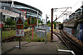
5
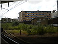
Site of depot, Drayton Park station
Prior to its takeover by British Rail in 1976, the Great Northern & City Railway was a self contained operation; I believe its train depot was here, on the west side of Drayton Park station. It is somewhat surprising that the land has not been built on.
Image: © Richard Vince
Taken: 16 Jul 2015
0.06 miles
7
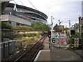
North end of Drayton Park station (2)
Looking north from the north end of platform 2, towards the junction with the East Coast Main Line at Finsbury Park. The large "6" sign indicates that six car trains (which presumably only just fit into the platform) must stop there, hence the mirror to enable drivers to see the train doors. On the left, the Emirates Stadium (home of Arsenal Football Club) towers over the railway.
Image: © Richard Vince
Taken: 16 Jul 2015
0.06 miles
9
Northwards from Drayton Park
Overshadowed now by the enormous Emirates Stadium of Arsenal Football Club, this shows the tracks at the north end of Drayton Park station, looking towards Finsbury Park. Until 1975, the tracks entered tunnels here to reach underground platforms at Finsbury Park. The line was at that time part of London Transport's Northern Line, and plans had been made for the tracks to surface here and be extended via Finsbury Park to East Finchley, Alexandra Palace, Edgware, and Bushey Heath. World War II intervened to prevent this plan ever being carried out, but in 1976 the line between Finsbury Park and Moorgate, the southern terminus, was transferred to British Railways, being served by full-size rolling stock from such places as Hertford North and New Barnet. These services still remain, now worked by First Capital Connect.
Image: © Dr Neil Clifton
Taken: 30 Jun 2010
0.06 miles
10
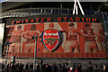
Mural, Emirates Stadium
One of a series of murals depicting distinguished players from Arsenal Football Club.
Image: © Jim Osley
Taken: 10 Dec 2011
0.07 miles