IMAGES TAKEN NEAR TO
Tollington Way, LONDON, N7 6RG
Introduction
This page details the photographs taken nearby to Tollington Way, N7 6RG by members of the Geograph project.
The Geograph project started in 2005 with the aim of publishing, organising and preserving representative images for every square kilometre of Great Britain, Ireland and the Isle of Man.

There are currently over 7.5m images from over14,400 individuals and you can help contribute to the project by visiting https://www.geograph.org.uk
Image Map (117 Images)


Getting Data...Please wait
Leaflet Map data © OpenStreetMap
Images are licensed for reuse under creativecommons.org/licenses/by-sa/2.0
Notes
- Clicking on the map will re-center to the selected point.
- The higher the marker number, the further away the image location is from the centre of the postcode.
Image Listing (117 Images Found)
Images are licensed for reuse under creativecommons.org/licenses/by-sa/2.0
Image
Details
Distance
6
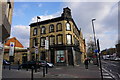
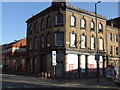
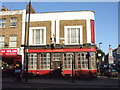
Nambucca, Holloway Road
A live music venue.
Image: © Bill Boaden
Taken: 16 Mar 2016
0.07 miles
7

Ordnance Survey Cut Mark
This OS cut mark can be found on No594 Holloway Road. It marks a point 33.010m above mean sea level.
Image: © Adrian Dust
Taken: 29 Jul 2016
0.07 miles
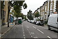
8
Nambucca, Holloway Road
At the junction with Tollington Way
Image: © Robin Sones
Taken: 13 Jun 2018
0.07 miles
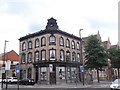
9
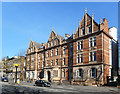
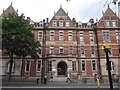
Former Hospital, Holloway Road
A fine Victorian frontage from the 1880s, this used to be the Royal Northern Hospital. This part of the building is still in use as a health centre.
Image: © Des Blenkinsopp
Taken: 14 Feb 2019
0.07 miles