IMAGES TAKEN NEAR TO
Huddleston Road, LONDON, N7 0RE
Introduction
This page details the photographs taken nearby to Huddleston Road, N7 0RE by members of the Geograph project.
The Geograph project started in 2005 with the aim of publishing, organising and preserving representative images for every square kilometre of Great Britain, Ireland and the Isle of Man.

There are currently over 7.5m images from over14,400 individuals and you can help contribute to the project by visiting https://www.geograph.org.uk
Image Map
Images are licensed for reuse under creativecommons.org/licenses/by-sa/2.0
Notes
- Clicking on the map will re-center to the selected point.
- The higher the marker number, the further away the image location is from the centre of the postcode.
Image Listing (58 Images Found)
Images are licensed for reuse under creativecommons.org/licenses/by-sa/2.0
Image
Details
Distance
1
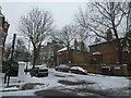
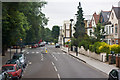
From Charlie Hotel to Shipton Place (5)
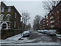
Looking from Anson Road into Huddleston Road.
Image: © Basher Eyre
Taken: 20 Jan 2013
0.03 miles
2
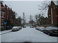
From Charlie Hotel to Shipton Place (6a)
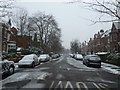
A snowy Huddleston Road
Image: © Basher Eyre
Taken: 20 Jan 2013
0.05 miles
3
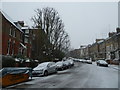
From Charlie Hotel to Shipton Place (6b)
Skip in Anson Road
Image: © Basher Eyre
Taken: 20 Jan 2013
0.06 miles
4
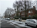
From Charlie Hotel to Shipton Place (4)
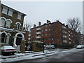
Houses in Anson Road
Image: © Basher Eyre
Taken: 20 Jan 2013
0.06 miles
5
From Charlie Hotel to Shipton Place (8)
Looking from Anson Road into Pleshey Road
Image: © Basher Eyre
Taken: 20 Jan 2013
0.07 miles
6
From Charlie Hotel to Shipton Place (3)
Looking from Dalmeny Road into Anson Road
Image: © Basher Eyre
Taken: 20 Jan 2013
0.08 miles
7
From Charlie Hotel to Shipton Place (7)
Approaching the junction of Anson and Pleshey Roads.
Image: © Basher Eyre
Taken: 20 Jan 2013
0.09 miles
8
From Charlie Hotel to Shipton Place (2)
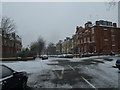
Crossroads of Anson and Dalmeny Roads
Image: © Basher Eyre
Taken: 20 Jan 2013
0.10 miles
9

St Benet & All Saints, Kentish Town - Interior
Image: © John Salmon
Taken: 16 May 2004
0.10 miles
10
Brecknock Road
Viewed from the top deck of a 390 bus en-route from Archway to Notting Hill Gate. The road on the left is Carleton Road whilst the one on the right is Leighton Grove. The public house, the sign of which is visible in the centre of the photo, is the Leighton Arms.
Brecknock Road is named after the Marquis of Camden who was also the Earl of Brecknock.
Image: © Martin Addison
Taken: 7 Jul 2010
0.11 miles