IMAGES TAKEN NEAR TO
Makepeace Avenue, LONDON, N6 6ES
Introduction
This page details the photographs taken nearby to Makepeace Avenue, N6 6ES by members of the Geograph project.
The Geograph project started in 2005 with the aim of publishing, organising and preserving representative images for every square kilometre of Great Britain, Ireland and the Isle of Man.

There are currently over 7.5m images from over14,400 individuals and you can help contribute to the project by visiting https://www.geograph.org.uk
Image Map
Images are licensed for reuse under creativecommons.org/licenses/by-sa/2.0
Notes
- Clicking on the map will re-center to the selected point.
- The higher the marker number, the further away the image location is from the centre of the postcode.
Image Listing (443 Images Found)
Images are licensed for reuse under creativecommons.org/licenses/by-sa/2.0
Image
Details
Distance
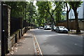
1
View of a house on Swain's Lane from Highgate Cemetery
Looking north-northwest.
Image: © Robert Lamb
Taken: 16 May 2015
0.03 miles
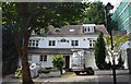
4
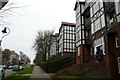
Holly Lodge Estate
This estate of mock tudor houses is built on the site of Holly Lodge, the former grand residence of the Burdett-Coutts family. It is situated opposite Highgate cemetery.
Image: © Nigel Mykura
Taken: 22 Dec 2008
0.03 miles
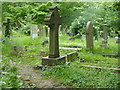
5

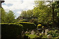
Gravestones, Highgate Cemetery
Taken close to the scene in Image, roughly opposite Makepeace Avenue.
Image: © Derek Harper
Taken: 12 Jun 2010
0.04 miles
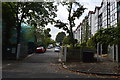
7
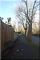
Bench on Swains Lane
Looking up Swains Lane towards Highgate beside the cemetery.
Image: © DS Pugh
Taken: 8 Dec 2017
0.05 miles
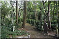
9

Highgate Cemetery
A view through the railings on Swain's Lane, of a woodland part of the cemetery.
Image: © Derek Harper
Taken: 12 Jun 2010
0.06 miles
10
Highgate East Cemetery
Highgate Cemetery in its original form (what is now the West Cemetery) opened in 1839, as part of a plan to provide seven large, modern cemeteries, now known as the "Magnificent Seven", around the outside of central London. In 1854 the area to the east of the original area across Swains Lane was bought to form the eastern part of the cemetery. This view is through the railings from Swains Lane. See also http://www.geograph.org.uk/photo/5779969
Image: © Marathon
Taken: 16 May 2018
0.06 miles