IMAGES TAKEN NEAR TO
Highgate West Hill, LONDON, N6 6DA
Introduction
This page details the photographs taken nearby to Highgate West Hill, N6 6DA by members of the Geograph project.
The Geograph project started in 2005 with the aim of publishing, organising and preserving representative images for every square kilometre of Great Britain, Ireland and the Isle of Man.

There are currently over 7.5m images from over14,400 individuals and you can help contribute to the project by visiting https://www.geograph.org.uk
Image Map
Images are licensed for reuse under creativecommons.org/licenses/by-sa/2.0
Notes
- Clicking on the map will re-center to the selected point.
- The higher the marker number, the further away the image location is from the centre of the postcode.
Image Listing (431 Images Found)
Images are licensed for reuse under creativecommons.org/licenses/by-sa/2.0
Image
Details
Distance
1
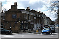
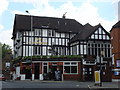
Highgate West Hill
Seen from High Street / North Road. Interestingly, the old street sign on the front of Stonebridge Estate Agents reads South Grove leading to West Hill. It was formerly the northern arm of South Grove (which still exists on the other side of Pond Square) but was later renamed as a continuation of Highgate West Hill with which it connected. I have been unable to ascertain when the renaming occurred.
Image: © Martin Addison
Taken: 23 Mar 2014
0.01 miles
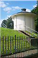
3
Highgate Reservoir, North London
Constructed here by the New River Company in 1854 when Highgate obtained its first piped water supply.
Image: © Jim Osley
Taken: 12 Jun 2010
0.01 miles
4
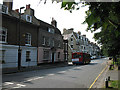
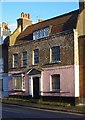
Highgate West Hill
Houses at the North end of Highgate West Hill. The pink fronted building in the centre is clearly suffering from subsidence. A 214 bus heads down the hill towards Gospel Oak, with its rear advertisement sliding out of the holder. Two beer cans on the post in the foreground bear witness to a pleasant evening the previous day.
Image: © Martin Addison
Taken: 1 Aug 2007
0.02 miles
5
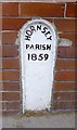
Old Boundary Marker by the B519, High Street, Hampstead Parish
Parish Boundary Marker by the B519, in parish of Hampstead (Camden District), corner of High Street and West Hill N6, inset into glazed brick wall of The Gatehouse PH above: MX_HORN02pb Image
Surveyed
Milestone Society National ID: MX_SPP04pb
Image: © Milestone Society
Taken: Unknown
0.02 miles
7
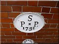
Old Boundary Marker by the B519, High Street, Highgate
Parish Boundary Marker by the B519, in parish of Hampstead (Camden District), corner of High Street and West Hill N6, inset into glazed brick wall of The Gatehouse PH. Below MX_SPP04pb Image
Inscription reads:- : HORNSEY / PARISH / 1859 :
Surveyed
Milestone Society National ID: MX_HORN02pb.
Image: © Milestone Society
Taken: Unknown
0.02 miles
8
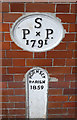
Parish Boundaries
A brace of parish boundary markers on the wall of the Gatehouse public house. Whilst the lower one is obvious the upper one is more cryptic and refers to the boundary of St Pancras Parish.
Image: © Martin Addison
Taken: 23 Mar 2014
0.03 miles
9
Highgate School Chapel and War Memorial
Both are Grade II listed. http://www.britishlistedbuildings.co.uk/en-358687-war-memorial-at-highgate-school-greater- & http://www.britishlistedbuildings.co.uk/en-358686-highgate-school-chapel-greater-london-au
Image: © N Chadwick
Taken: 25 Aug 2016
0.03 miles
10
Pond House, Highgate
Grade II listed residence, described at this http://list.english-heritage.org.uk/resultsingle.aspx?uid=1379051.
Image: © Jim Osley
Taken: 28 Dec 2014
0.03 miles