IMAGES TAKEN NEAR TO
Swains Lane, LONDON, N6 6AG
Introduction
This page details the photographs taken nearby to Swains Lane, N6 6AG by members of the Geograph project.
The Geograph project started in 2005 with the aim of publishing, organising and preserving representative images for every square kilometre of Great Britain, Ireland and the Isle of Man.

There are currently over 7.5m images from over14,400 individuals and you can help contribute to the project by visiting https://www.geograph.org.uk
Image Map
Images are licensed for reuse under creativecommons.org/licenses/by-sa/2.0
Notes
- Clicking on the map will re-center to the selected point.
- The higher the marker number, the further away the image location is from the centre of the postcode.
Image Listing (177 Images Found)
Images are licensed for reuse under creativecommons.org/licenses/by-sa/2.0
Image
Details
Distance
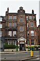
1
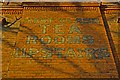
Painted wall advertisement, or "ghostsign", Highgate
Image: © Jim Osley
Taken: 9 Jan 2011
0.01 miles
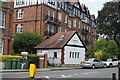
2
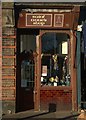
Charity shop, Highgate
Interestingly detailed shopfront.
Image: © Jim Osley
Taken: 9 Jan 2011
0.01 miles
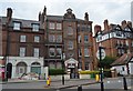
3

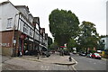
Swains Lane, Highgate
Swains Lane in Highgate, North London.
Image: © Malc McDonald
Taken: 7 Mar 2015
0.01 miles
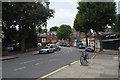
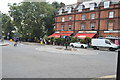
6
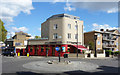
The Carob Tree
Pub on the corner of Swains Lane and Highgate Road.
An unusual name for a pub, the Carob is a Mediterranean tree which has pods that produce a sweet substance similar to chocolate.
Image: © Des Blenkinsopp
Taken: 18 Apr 2017
0.03 miles