IMAGES TAKEN NEAR TO
Orchard Road, LONDON, N6 5TR
Introduction
This page details the photographs taken nearby to Orchard Road, N6 5TR by members of the Geograph project.
The Geograph project started in 2005 with the aim of publishing, organising and preserving representative images for every square kilometre of Great Britain, Ireland and the Isle of Man.

There are currently over 7.5m images from over14,400 individuals and you can help contribute to the project by visiting https://www.geograph.org.uk
Image Map
Images are licensed for reuse under creativecommons.org/licenses/by-sa/2.0
Notes
- Clicking on the map will re-center to the selected point.
- The higher the marker number, the further away the image location is from the centre of the postcode.
Image Listing (220 Images Found)
Images are licensed for reuse under creativecommons.org/licenses/by-sa/2.0
Image
Details
Distance
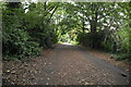
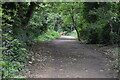
3
Old railway track now a footpath and cycling route between Highgate and Finsbury Park
Image: © Rob Purvis
Taken: 4 Aug 2018
0.02 miles
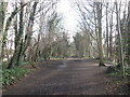
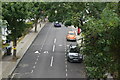
6
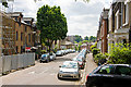
Holmesdale Road
A quiet sidestreet with speed humps behind the bustle of Archway Road .
Image: © Martin Addison
Taken: 22 May 2009
0.05 miles
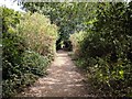
7
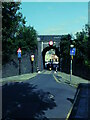
Northwood Road Narrow Underbridge
Northwood Road narrows to pass under the old railway bridge that today carries the Parkland Walk. It remains a two way road and pedestrian pathway together. I think it's a little gem.
Image: © John Kingdon
Taken: 26 Sep 2023
0.05 miles
8
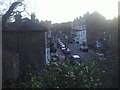
Northwood Road from the old rail bridge
Image: © David Howard
Taken: 5 Mar 2013
0.05 miles
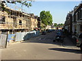
10
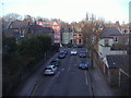
Northwood Road from the old rail bridge
Image: © David Howard
Taken: 5 Mar 2013
0.06 miles