IMAGES TAKEN NEAR TO
Highgate Avenue, LONDON, N6 5RX
Introduction
This page details the photographs taken nearby to Highgate Avenue, N6 5RX by members of the Geograph project.
The Geograph project started in 2005 with the aim of publishing, organising and preserving representative images for every square kilometre of Great Britain, Ireland and the Isle of Man.

There are currently over 7.5m images from over14,400 individuals and you can help contribute to the project by visiting https://www.geograph.org.uk
Image Map
Images are licensed for reuse under creativecommons.org/licenses/by-sa/2.0
Notes
- Clicking on the map will re-center to the selected point.
- The higher the marker number, the further away the image location is from the centre of the postcode.
Image Listing (249 Images Found)
Images are licensed for reuse under creativecommons.org/licenses/by-sa/2.0
Image
Details
Distance
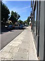
1

Ordnance Survey Cut Mark
This OS cut mark can be found on No253 Archway Road. It marks a point 95.380m above mean sea level.
Image: © Adrian Dust
Taken: 31 Jul 2016
0.04 miles
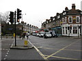
3
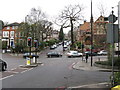
Highgate: Jackson's Lane
The former Wesleyan Methodist church on the corner is now a community centre.
Image: © Dr Neil Clifton
Taken: 20 Jan 2012
0.04 miles
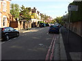
4

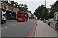
Highgate: Highgate Avenue: looking south from the very busy Archway Road
Image: © Dr Neil Clifton
Taken: 20 Jan 2012
0.04 miles
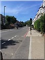
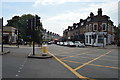
7
Highgate: Archway Road
Looking towards Archway, that is, southeast. Archway Road is part of the A1.
Image: © Dr Neil Clifton
Taken: 20 Jan 2012
0.04 miles