IMAGES TAKEN NEAR TO
Milton Park, LONDON, N6 5PZ
Introduction
This page details the photographs taken nearby to Milton Park, N6 5PZ by members of the Geograph project.
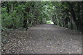
The Geograph project started in 2005 with the aim of publishing, organising and preserving representative images for every square kilometre of Great Britain, Ireland and the Isle of Man.

There are currently over 7.5m images from over14,400 individuals and you can help contribute to the project by visiting https://www.geograph.org.uk
Image Map
Images are licensed for reuse under creativecommons.org/licenses/by-sa/2.0
Notes
- Clicking on the map will re-center to the selected point.
- The higher the marker number, the further away the image location is from the centre of the postcode.
Image Listing (176 Images Found)
Images are licensed for reuse under creativecommons.org/licenses/by-sa/2.0
Image
Details
Distance
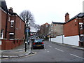
1
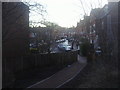
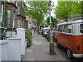
Milton Park
Typical Victorian houses in Highgate.
Image: © David Howard
Taken: 7 May 2009
0.02 miles
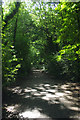
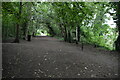
3
Parkland Walk: Steps leading down to Northwood Road
Image: © Dr Neil Clifton
Taken: 7 Jan 2012
0.03 miles
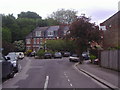
4
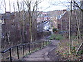
Milton Park from Parkland Walk exit
The path from what was a railway line until the 1950s.
Image: © David Howard
Taken: 5 Mar 2013
0.03 miles
5
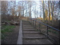
Steps from Milton Park to Parkland Walk
Image: © David Howard
Taken: 5 Mar 2013
0.03 miles
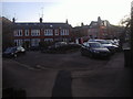
8
Langdon Park Road
Typical Highgate road.
Image: © David Howard
Taken: 7 May 2009
0.05 miles