IMAGES TAKEN NEAR TO
Hornsey Lane, LONDON, N6 5NS
Introduction
This page details the photographs taken nearby to Hornsey Lane, N6 5NS by members of the Geograph project.
The Geograph project started in 2005 with the aim of publishing, organising and preserving representative images for every square kilometre of Great Britain, Ireland and the Isle of Man.

There are currently over 7.5m images from over14,400 individuals and you can help contribute to the project by visiting https://www.geograph.org.uk
Image Map
Images are licensed for reuse under creativecommons.org/licenses/by-sa/2.0
Notes
- Clicking on the map will re-center to the selected point.
- The higher the marker number, the further away the image location is from the centre of the postcode.
Image Listing (162 Images Found)
Images are licensed for reuse under creativecommons.org/licenses/by-sa/2.0
Image
Details
Distance
1
Sunnyside Road at the junction of Hornsey Lane
Another petrol station has recently gone west and is now yet another car wash. It had been there as long as I remember (ie over 40 years) and is now just a memory.
Image: © David Howard
Taken: 17 Oct 2013
0.01 miles
2
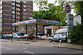
Crystal Clear
Crystal Clear Motors occupies a Cyma service station that stopped selling fuel quite some time ago, if the price of unleaded petrol on the board is anything to go by. Located on Sunnyside Road, the staff seem to be enjoying the lunchtime sun.
Image: © Martin Addison
Taken: 22 May 2009
0.03 miles
3
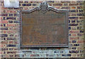
Plaque, Hornsey Lane Estate
The Hornsey Lane Estate is an extensive inter-war Neo-Georgian housing estate built for the London Borough of Islington to the designs of architect E.C.P. Monson.
Image: © Jim Osley
Taken: 26 Oct 2016
0.06 miles
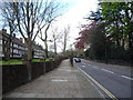
4
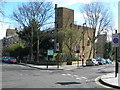
New Orleans Estate
On the corner of Hornsey Lane and Sunnyside Road.
Image: © Danny P Robinson
Taken: 18 Mar 2007
0.06 miles
6
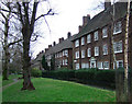
Hornsey Lane Estate
Local authority housing estate built in the late 1930s to a design by E.C.P. Monson. This is recorded on a nearby plaque, i.e. Image
Image: © Jim Osley
Taken: 22 Jan 2018
0.07 miles
7
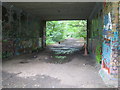
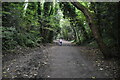
Crouch End: Former railway line
This is the trackbed of the former Great Northern Railway line from Finsbury Park to Alexandra Palace via Highgate, as viewed looking west under the Crouch End Hill road bridge, from the site of the former Crouch End railway station. The track was lifted in 1972, some 18 years after the station closed. The trackbed is now a public footpath called Parkland Walk and the whole of the former railway property is the Railway Fields Local Nature Reserve.
Image: © Nigel Cox
Taken: 20 Jun 2007
0.08 miles
8
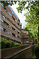
Iberia House and New Orleans Walk
New Orleans Walk in the foreground runs parallel to Hornsey Lane before passing between Iberia House on the left and Munroe House.
Image: © Martin Addison
Taken: 22 May 2009
0.08 miles