IMAGES TAKEN NEAR TO
Highgate Hill, LONDON, N6 5HE
Introduction
This page details the photographs taken nearby to Highgate Hill, N6 5HE by members of the Geograph project.
The Geograph project started in 2005 with the aim of publishing, organising and preserving representative images for every square kilometre of Great Britain, Ireland and the Isle of Man.

There are currently over 7.5m images from over14,400 individuals and you can help contribute to the project by visiting https://www.geograph.org.uk
Image Map
Images are licensed for reuse under creativecommons.org/licenses/by-sa/2.0
Notes
- Clicking on the map will re-center to the selected point.
- The higher the marker number, the further away the image location is from the centre of the postcode.
Image Listing (347 Images Found)
Images are licensed for reuse under creativecommons.org/licenses/by-sa/2.0
Image
Details
Distance
1
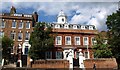
Cromwell House, Highgate
An impressive early C17 house with 7 bays set above Highgate Hill http://www.imagesofengland.org.uk/details/default.aspx?id=201359 . There have been additions since, like the C18 doorcase and the C19 cupola. The house was built for Richard Sprignall who, like the illustrious John Gilpin, was a trainband (militia) captain, which would presumably have put him on Cromwell's side in the civil war, but the name of the house arrived only in 1833, when it became a school and later a convalescent home for sick children. http://www.british-history.ac.uk/report.aspx?compid=22520 gives more historical and architectural detail.
Image: © Derek Harper
Taken: 12 Jun 2010
0.02 miles
2
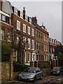
Housing terrace, Highgate Hill
Grade II* listed houses on Highgate Hill, described at this https://historicengland.org.uk/listing/the-list/list-entry/1079235.
Image: © Jim Osley
Taken: 24 Dec 2016
0.02 miles

4
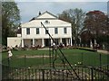
Lauderdale House and the sundial
In Waterlow Park
Image: © David Smith
Taken: 27 Apr 2010
0.02 miles
5
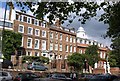
Houses on The Bank
A group of striking buildings above Highgate Hill; on the right is Image The pair to its left are Ireton House (right) and Lyndale House http://www.britishlistedbuildings.co.uk/en-201362-106a-hornsey ; left of these is no 110 http://www.britishlistedbuildings.co.uk/en-201364-110-hornsey .
Image: © Derek Harper
Taken: 12 Jun 2010
0.03 miles

7

View of a church building on Cromwell Road converted to flats from Highgate Hill
Looking north-northwest.
Image: © Robert Lamb
Taken: 16 May 2015
0.03 miles
8
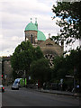
Highgate Hill N6
Looking towards the junction of Dartmouth Park Hill NW6 and St Joseph's Church
Image: © Robin Sones
Taken: 1 Aug 2006
0.03 miles
9
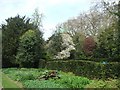
Waterlow Park
This area was the former kitchen garden
Image: © David Smith
Taken: 27 Apr 2010
0.03 miles
10
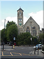
Former Highgate Presbyterian Church, Cromwell Avenue
Built in 1887. Converted into residential use.
Image: © Jim Osley
Taken: 1 Jun 2017
0.04 miles