IMAGES TAKEN NEAR TO
Muswell Hill Road, LONDON, N6 5FJ
Introduction
This page details the photographs taken nearby to Muswell Hill Road, N6 5FJ by members of the Geograph project.
The Geograph project started in 2005 with the aim of publishing, organising and preserving representative images for every square kilometre of Great Britain, Ireland and the Isle of Man.

There are currently over 7.5m images from over14,400 individuals and you can help contribute to the project by visiting https://www.geograph.org.uk
Image Map
Images are licensed for reuse under creativecommons.org/licenses/by-sa/2.0
Notes
- Clicking on the map will re-center to the selected point.
- The higher the marker number, the further away the image location is from the centre of the postcode.
Image Listing (313 Images Found)
Images are licensed for reuse under creativecommons.org/licenses/by-sa/2.0
Image
Details
Distance
2
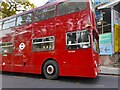
1975 bus on Archway Road, Highgate
I was by Highgate Station and saw an odd bus and quickly got my phone out. It is a 43 registered in 1975. It turns out they had a running day in Muswell Hill to commemorate the 30th year of the closure of their bus garage. Had I known I could have got all of them.
Image: © David Howard
Taken: 7 Nov 2021
0.02 miles
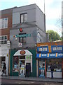
4
Highgate Post Office, Archway Road, Highgate
Image: © Alexander P Kapp
Taken: 22 Jul 2012
0.02 miles
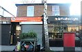
5
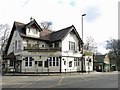
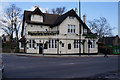
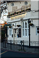
The Woodman, Archway Road / Muswell Hill Road, N6
See https://www.the-woodman.com/ . The view is looking down Archway Road towards the exit at the top of an escalator from Highgate tube station - see also Image
Image: © Mike Quinn
Taken: 26 Feb 2020
0.03 miles
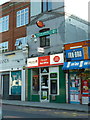
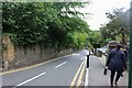
7
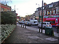
Archway Road, Highgate
Heading south near the junction of Shepherds Hill.
Image: © David Howard
Taken: 4 Dec 2008
0.04 miles
8
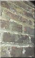
Ordnance Survey Cut Mark
This OS cut mark can be found to the right of the entrance to Nos. 7-9 Southwood Hall and behind the bus shelter. It marks a point 104.668m above mean sea level.
Image: © Adrian Dust
Taken: 9 Aug 2016
0.04 miles
10
Wood Lane, Highgate
The side entrance to Highgate Station is on the right. A bunch of people just got off a bus and all went into there.
Image: © David Howard
Taken: 15 Jun 2019
0.04 miles