IMAGES TAKEN NEAR TO
Stanhope Road, LONDON, N6 5DB
Introduction
This page details the photographs taken nearby to Stanhope Road, N6 5DB by members of the Geograph project.
The Geograph project started in 2005 with the aim of publishing, organising and preserving representative images for every square kilometre of Great Britain, Ireland and the Isle of Man.

There are currently over 7.5m images from over14,400 individuals and you can help contribute to the project by visiting https://www.geograph.org.uk
Image Map
Images are licensed for reuse under creativecommons.org/licenses/by-sa/2.0
Notes
- Clicking on the map will re-center to the selected point.
- The higher the marker number, the further away the image location is from the centre of the postcode.
Image Listing (125 Images Found)
Images are licensed for reuse under creativecommons.org/licenses/by-sa/2.0
Image
Details
Distance
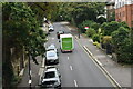
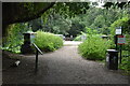
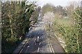
2
View from Parkland Walk: Looking southeast
Stanhope Road.
Image: © Dr Neil Clifton
Taken: 7 Jan 2012
0.02 miles
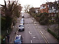
3
Housing on Stanhope Road
A mix of styles on this steeply inclined road. Taken from the Parkland Walk.
Image: © Martin Addison
Taken: 22 May 2009
0.03 miles
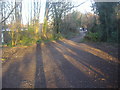
4
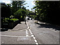
Stanhope Road
Stanhope Road passing Avenue Road to go under the old railway bridge which now carries the Parkland Walk
Image: © Shaun Ferguson
Taken: 29 Apr 2009
0.03 miles
7
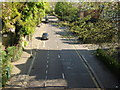
Stanhope Road from Parkland Walk
Seen from the top of a former Great Northern Railway bridge that is now part of Parkland Walk
Image: © Oxyman
Taken: 22 Apr 2009
0.04 miles
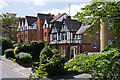
8
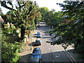
Highgate: Stanhope Road, N6
Viewed looking from the overbridge of the former Great Northern Railway line between Crouch End and Highgate stations.
Image: © Nigel Cox
Taken: 26 Sep 2008
0.04 miles
10
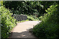
Bridge Over Stanhope Road
Looking along the Parkland Walk that follows the course of the dismantled Finsbury Park to Highgate section of the Northern Heights branch. The footpath forms part of the Capital Ring of footpaths. This bridge is probably a modern replacement of the original railway bridge, though the bridge piers are original.
Image: © Martin Addison
Taken: 22 May 2009
0.05 miles