IMAGES TAKEN NEAR TO
Claremont Road, LONDON, N6 5DA
Introduction
This page details the photographs taken nearby to Claremont Road, N6 5DA by members of the Geograph project.
The Geograph project started in 2005 with the aim of publishing, organising and preserving representative images for every square kilometre of Great Britain, Ireland and the Isle of Man.

There are currently over 7.5m images from over14,400 individuals and you can help contribute to the project by visiting https://www.geograph.org.uk
Image Map (161 Images)


Getting Data...Please wait
Leaflet Map data © OpenStreetMap
Images are licensed for reuse under creativecommons.org/licenses/by-sa/2.0
Notes
- Clicking on the map will re-center to the selected point.
- The higher the marker number, the further away the image location is from the centre of the postcode.
Image Listing (161 Images Found)
Images are licensed for reuse under creativecommons.org/licenses/by-sa/2.0
Image
Details
Distance
5
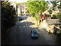
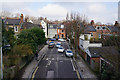
Northwood Road from Parkland Walk
Seen from the top of a former Great Northern Railway bridge that is now part of Parkland Walk
Image: © Oxyman
Taken: 22 Apr 2009
0.07 miles
6
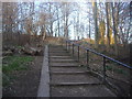
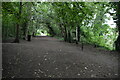
Steps from Milton Park to Parkland Walk
Image: © David Howard
Taken: 5 Mar 2013
0.07 miles
7
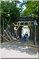
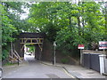
Bridge over Northwood Road
This very narrow bridge carries the trackbed of the dismantled Finsbury Park to Highgate section of the Northern Heights branch. Wooden bracing has been added as the retaining walls have developed cracks. The bridge is now used by the Parkland Walk, which is part of the Capital Ring.
Image: © Martin Addison
Taken: 22 May 2009
0.07 miles
8
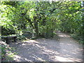
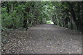
Highgate: Former railway line
This is the trackbed of the former Great Northern Railway line from Finsbury Park to Alexandra Palace via Highgate, as viewed looking west from the Stanhope Road bridge. The track was lifted in 1972. The trackbed is now a public footpath that forms a section of the 125 kilometre long Capital Ring http://www.walklondon.org.uk/route.asp?R=1 . The whole of the former railway property is also now the Railway Fields Local Nature Reserve.
Image: © Nigel Cox
Taken: 26 Sep 2008
0.07 miles
10
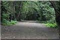
Old rail bridge in Highgate
The railway which closed in the 1950s is now Parkland Walk.
Image: © David Howard
Taken: 7 May 2009
0.08 miles