IMAGES TAKEN NEAR TO
Archway Road, LONDON, N6 5BS
Introduction
This page details the photographs taken nearby to Archway Road, N6 5BS by members of the Geograph project.
The Geograph project started in 2005 with the aim of publishing, organising and preserving representative images for every square kilometre of Great Britain, Ireland and the Isle of Man.

There are currently over 7.5m images from over14,400 individuals and you can help contribute to the project by visiting https://www.geograph.org.uk
Image Map (246 Images)


Leaflet Map data © OpenStreetMap
Images are licensed for reuse under creativecommons.org/licenses/by-sa/2.0
Notes
- Clicking on the map will re-center to the selected point.
- The higher the marker number, the further away the image location is from the centre of the postcode.
Image Listing (246 Images Found)
Images are licensed for reuse under creativecommons.org/licenses/by-sa/2.0
Image
Details
Distance
2

Highgate International Church
Until March 2013 known as Cholmeley Evangelical Church.
Image: © Jim Osley
Taken: 23 Jun 2013
0.01 miles
6

Ordnance Survey Cut Mark
This OS cut mark can be found on No253 Archway Road. It marks a point 95.380m above mean sea level.
Image: © Adrian Dust
Taken: 31 Jul 2016
0.02 miles

9
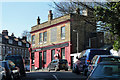
The Boogaloo, N6
On the corner of Archway Road and Holmesdale Road.
Image: © Robin Webster
Taken: 19 Mar 2011
0.03 miles
10
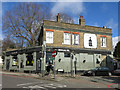
The Boogaloo, Archway Road / Holmesdale Road, N6
Image: © Mike Quinn
Taken: 26 Feb 2020
0.03 miles