IMAGES TAKEN NEAR TO
North Grove, LONDON, N6 4SJ
Introduction
This page details the photographs taken nearby to North Grove, N6 4SJ by members of the Geograph project.
The Geograph project started in 2005 with the aim of publishing, organising and preserving representative images for every square kilometre of Great Britain, Ireland and the Isle of Man.

There are currently over 7.5m images from over14,400 individuals and you can help contribute to the project by visiting https://www.geograph.org.uk
Image Map
Images are licensed for reuse under creativecommons.org/licenses/by-sa/2.0
Notes
- Clicking on the map will re-center to the selected point.
- The higher the marker number, the further away the image location is from the centre of the postcode.
Image Listing (266 Images Found)
Images are licensed for reuse under creativecommons.org/licenses/by-sa/2.0
Image
Details
Distance
2

Former fire station building, Highgate
According to this http://www.hampsteadheath.net/old-fire-station.html , the fire station was built in 1894: it has been converted into residential accommodation.
Image: © Jim Osley
Taken: 11 Dec 2015
0.05 miles
3
St Michael's Primary School, Highgate
Grade II listed school, built in 1852 to the designs of architect Anthony Salvin.
Image: © Jim Osley
Taken: 19 Feb 2016
0.05 miles
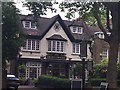
4
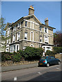
Town House
A large three storey house on the corner of Hampstead Lane and North Grove. I hope the Ka's handbrake is in good order!
Image: © Martin Addison
Taken: 14 Apr 2007
0.06 miles
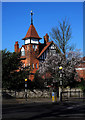
5

The Red Lion & Sun
Grade II listed. http://www.britishlistedbuildings.co.uk/en-201462-23-north-road-n6-greater-london-authorit
Image: © N Chadwick
Taken: 25 Aug 2016
0.06 miles
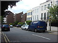
6
Former fire station, Highgate
According to this http://www.hampsteadheath.net/old-fire-station.html , the fire station was built in 1894: it has been converted into residential accommodation.
Image: © Jim Osley
Taken: 19 Feb 2016
0.06 miles
7

Ordnance Survey Cut Mark
This OS cut mark can be found on the south face of the Red Lion & Sun PH. It marks a point 129.623m above mean sea level.
Image: © Adrian Dust
Taken: 31 Jul 2016
0.06 miles