IMAGES TAKEN NEAR TO
Hampstead Lane, LONDON, N6 4SB
Introduction
This page details the photographs taken nearby to Hampstead Lane, N6 4SB by members of the Geograph project.
The Geograph project started in 2005 with the aim of publishing, organising and preserving representative images for every square kilometre of Great Britain, Ireland and the Isle of Man.

There are currently over 7.5m images from over14,400 individuals and you can help contribute to the project by visiting https://www.geograph.org.uk
Image Map
Images are licensed for reuse under creativecommons.org/licenses/by-sa/2.0
Notes
- Clicking on the map will re-center to the selected point.
- The higher the marker number, the further away the image location is from the centre of the postcode.
Image Listing (268 Images Found)
Images are licensed for reuse under creativecommons.org/licenses/by-sa/2.0
Image
Details
Distance
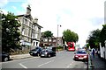
1
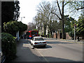
Hampstead Lane
A 210 bus stops to pick up passengers on its way to Brent Cross via Golders Green.
Image: © Martin Addison
Taken: 14 Apr 2007
0.01 miles
2
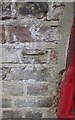
Ordnance Survey Cut Mark
This OS cut mark can be found next to the post box on Hampstead Lane. it marks a point 120.803m above mean sea level.
Image: © Adrian Dust
Taken: 11 Aug 2016
0.03 miles
3
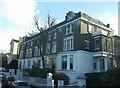
Grove Lodge, 9-11 Hampstead Lane
A residential unit along the road, consisting of flats.
Image: © David Anstiss
Taken: 27 Jan 2013
0.05 miles
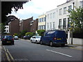
4
Hampstead Lane
Looking up the hill towards the junction where Hampstead Lane (the B519) meets Highgate High Street.
Image: © Nigel Mykura
Taken: 23 Aug 2015
0.06 miles
5
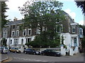
Grove Lodge, 9-11 Hampstead Lane
A residential unit consisting of flats
Image: © Oxyman
Taken: 27 Jun 2009
0.06 miles
7
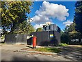
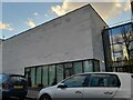
Mystery building on Stormont Road, Highgate
It'll either be a house or flats but too early to know.
Image: © David Howard
Taken: 18 Sep 2023
0.07 miles
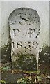
8
Old Boundary Marker by The Grove, Hampstead
Parish Boundary Marker by the UC road, in parish of Hampstead (Camden District), The Grove N6, against side wall of no 5 Hampstead Lane to right of MX_SPP02pb Image
Surveyed
Milestone Society National ID: MX_HORN04pb
Image: © M Faherty
Taken: Unknown
0.08 miles
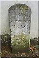
9
Old Boundary Marker by The Grove, Hampstead
Parish Boundary Marker by the UC road, in parish of Hampstead (Camden District), The Grove N6, against side wall of No 5 Hampstead Lane to left of: MX_HORN04pb Image
Inscription reads:-
Sᵀ
P P
1839
Surveyed
Milestone Society National ID: MX_SPP02pb
Image: © M Faherty
Taken: 23 Jun 2012
0.08 miles