IMAGES TAKEN NEAR TO
Talbot Road, LONDON, N6 4QR
Introduction
This page details the photographs taken nearby to Talbot Road, N6 4QR by members of the Geograph project.
The Geograph project started in 2005 with the aim of publishing, organising and preserving representative images for every square kilometre of Great Britain, Ireland and the Isle of Man.

There are currently over 7.5m images from over14,400 individuals and you can help contribute to the project by visiting https://www.geograph.org.uk
Image Map
Images are licensed for reuse under creativecommons.org/licenses/by-sa/2.0
Notes
- Clicking on the map will re-center to the selected point.
- The higher the marker number, the further away the image location is from the centre of the postcode.
Image Listing (246 Images Found)
Images are licensed for reuse under creativecommons.org/licenses/by-sa/2.0
Image
Details
Distance
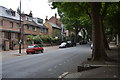
1
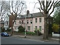
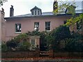
Former schoolhouse in North Hill, Highgate
Image: © David Smith
Taken: 27 Apr 2010
0.02 miles
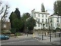
2
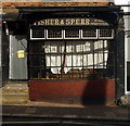
Abandoned second-hand bookshop, Highgate
Sadly, a common sight, the closed second-hand bookshop. This example opened in 1947 and closed in 2010 following the death of its elderly eccentric owner. For more http://library-keeper.livejournal.com/9021.html
Image: © Jim Osley
Taken: 7 Oct 2010
0.02 miles
3
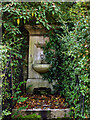
Drinking fountain, Highgate Hill
One of many such fountains sponsored by Metropolitan Drinking Fountain and Cattle Trough Association (founded in London in 1859).
Image: © Jim Osley
Taken: 7 Oct 2010
0.03 miles
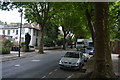
7
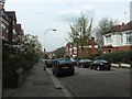
Pedestrian crossing and passage to The Park
From Broadlands Road, pedestrians can cross and take the short passage to The Park
Image: © David Smith
Taken: 27 Apr 2010
0.05 miles
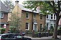
10

Ordnance Survey Cut Mark
This OS cut mark can be found on the wall to the south side of The Park. It marks a point 120.238m above mean sea level.
Image: © Adrian Dust
Taken: 31 Jul 2016
0.05 miles