IMAGES TAKEN NEAR TO
Compton Avenue, LONDON, N6 4LH
Introduction
This page details the photographs taken nearby to Compton Avenue, N6 4LH by members of the Geograph project.
The Geograph project started in 2005 with the aim of publishing, organising and preserving representative images for every square kilometre of Great Britain, Ireland and the Isle of Man.

There are currently over 7.5m images from over14,400 individuals and you can help contribute to the project by visiting https://www.geograph.org.uk
Image Map
Images are licensed for reuse under creativecommons.org/licenses/by-sa/2.0
Notes
- Clicking on the map will re-center to the selected point.
- The higher the marker number, the further away the image location is from the centre of the postcode.
Image Listing (217 Images Found)
Images are licensed for reuse under creativecommons.org/licenses/by-sa/2.0
Image
Details
Distance
3
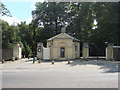
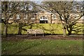
Kenwood House & Estate, East Lodge
This structure guards the gated entrance providing pedestrian and service access to Kenwood's grounds
Image: © Oxyman
Taken: 27 Jun 2009
0.07 miles
4

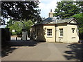
East Lodge, Kenwood House
Late 18th century lodge - Grade II listed, described at this https://historicengland.org.uk/listing/the-list/list-entry/1079225 .
Image: © Jim Osley
Taken: 2 Oct 2014
0.08 miles
5
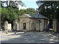
Kenwood House : East Lodge
Grade II listed lodge to Grade I listed house. c1795. Architect: George Saunders. Description at this https://historicengland.org.uk/listing/the-list/list-entry/1378705.
Image: © Jim Osley
Taken: 3 Aug 2020
0.08 miles
6
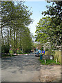
Courtenay Avenue
One of two private cul-de-saq's along Hampstead Lane. The barriers prevent unwanted persons from accessing. There is a manned security office just out of shot on the left - very Checkpoint Charlie!
Image: © Martin Addison
Taken: 14 Apr 2007
0.08 miles
7

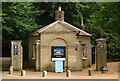
Ordnance Survey Cut Mark
This OS cut mark can be found on a post at the entrance to Kenwood House. It marks a point 116.320m above mean sea level.
Image: © Adrian Dust
Taken: 30 Jul 2016
0.09 miles
8
Hampstead Heath : Kenwood House stable block
Image: © Jim Osley
Taken: 12 Jan 2020
0.09 miles
9

Red phonebox at the entrance to Kenwood, Hampstead Lane
This was the entrance to one of three free public car parks for Kenwood, and the first to close entirely, as seen by the presence of the gate. The second closure was the car park next to the main house which was accessed through the main entrance and along a system of narrow one way roads. The third and final main car park was left and then began charging, around £1 an hour in 2012. Of course this results in many people using the surrounding roads as at present it is still free to park in the area.
Image: © David Howard
Taken: 23 Jul 2008
0.11 miles
10

Ordnance Survey Cut Mark
This OS cut mark can be found behind the phone box on Hampstead Lane. It marks a point 111.990m above mean sea level.
Image: © Adrian Dust
Taken: 30 Jul 2016
0.11 miles