IMAGES TAKEN NEAR TO
Sheldon Avenue, LONDON, N6 4JT
Introduction
This page details the photographs taken nearby to Sheldon Avenue, N6 4JT by members of the Geograph project.
The Geograph project started in 2005 with the aim of publishing, organising and preserving representative images for every square kilometre of Great Britain, Ireland and the Isle of Man.

There are currently over 7.5m images from over14,400 individuals and you can help contribute to the project by visiting https://www.geograph.org.uk
Image Map
Images are licensed for reuse under creativecommons.org/licenses/by-sa/2.0
Notes
- Clicking on the map will re-center to the selected point.
- The higher the marker number, the further away the image location is from the centre of the postcode.
Image Listing (74 Images Found)
Images are licensed for reuse under creativecommons.org/licenses/by-sa/2.0
Image
Details
Distance
1
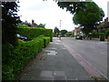
Sheldon Avenue, Highgate
Sheldon Avenue leads from Hampstead Lane to Archway Road. This is near the southern end.
Image: © Marathon
Taken: 17 Jun 2015
0.05 miles
4

Ordnance Survey Cut Mark
This OS cut mark can be found on the wall to the south of Hampstead Lane. It marks a point 106.461m above mean sea level.
Image: © Adrian Dust
Taken: 30 Jul 2016
0.13 miles
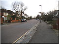
5

Hampstead Lane (B519) London NW3
Looking across from quite close to Kenwood.
Image: © Christine Matthews
Taken: 17 Oct 2010
0.13 miles
6
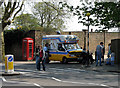
A 99 Please!
An icecream seller plies his trade at one of the footpath entrances to Kenwood house beside Hampstead Lane. He seems to have picked a good spot as the entrance is clearly popular.
Image: © Martin Addison
Taken: 14 Apr 2007
0.13 miles
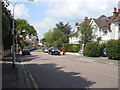
7
Hampstead Heath
Shot taken near an entrance from Hampstead Lane to the north of the heath
Image: © Peter S
Taken: 21 Apr 2010
0.14 miles
9

Red phonebox at the entrance to Kenwood, Hampstead Lane
This was the entrance to one of three free public car parks for Kenwood, and the first to close entirely, as seen by the presence of the gate. The second closure was the car park next to the main house which was accessed through the main entrance and along a system of narrow one way roads. The third and final main car park was left and then began charging, around £1 an hour in 2012. Of course this results in many people using the surrounding roads as at present it is still free to park in the area.
Image: © David Howard
Taken: 23 Jul 2008
0.15 miles
10

Ordnance Survey Cut Mark
This OS cut mark can be found behind the phone box on Hampstead Lane. It marks a point 111.990m above mean sea level.
Image: © Adrian Dust
Taken: 30 Jul 2016
0.15 miles