IMAGES TAKEN NEAR TO
Hillcrest, LONDON, N6 4HD
Introduction
This page details the photographs taken nearby to Hillcrest, N6 4HD by members of the Geograph project.
The Geograph project started in 2005 with the aim of publishing, organising and preserving representative images for every square kilometre of Great Britain, Ireland and the Isle of Man.

There are currently over 7.5m images from over14,400 individuals and you can help contribute to the project by visiting https://www.geograph.org.uk
Image Map
Images are licensed for reuse under creativecommons.org/licenses/by-sa/2.0
Notes
- Clicking on the map will re-center to the selected point.
- The higher the marker number, the further away the image location is from the centre of the postcode.
Image Listing (306 Images Found)
Images are licensed for reuse under creativecommons.org/licenses/by-sa/2.0
Image
Details
Distance
1
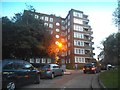
Block of flats on Hillcrest, Highgate
This is not on Streetview as a private road. There are three of these, I think this is the right one marked.
Image: © David Howard
Taken: 31 Oct 2014
0.00 miles
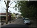
2
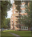
Apartment blocks, Hillcrest Estate
Built in 1948 Hillcrest Estate was built to the design of architects T. P. Bennett & Son.
Image: © Jim Osley
Taken: 12 Jul 2017
0.02 miles
3
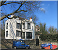
Old House, Jacksons Lane, Highgate
Highgate was an old village long before the spread of Victorian London engulfed it, so you get pre suburban properties like this one.
Image: © Des Blenkinsopp
Taken: 17 Mar 2016
0.03 miles
4

Decorative detail, former Highgate sorting office
Detail on the elevation of the former Victorian sorting office (1888), Southwood Lane, Highgate, North London
Image: © Jim Osley
Taken: 13 May 2010
0.03 miles
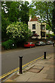
5
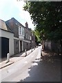
Jacksons Lane, Highgate
Image shows the point where the road narrows considerably.
Image: © Jim Osley
Taken: 17 Jun 2016
0.04 miles
7
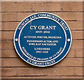
Highgate : Cy Grant plaque
"His was the first black face to be regularly seen on British television, singing the news on the BBC TONIGHT programme." - https://cygrant.com/about-cy-grant/
Image: © Jim Osley
Taken: 16 Nov 2020
0.04 miles
8
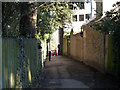
Alley from Southwood Lane to North Hill, N6
Looking towards Southwood Lane.
Image: © Robin Webster
Taken: 19 Mar 2011
0.05 miles
10

Ordnance Survey Cut Mark
This OS cut mark can be found at the junction of Southwood Lane and Jacksons Lane. It marks a point 122.470m above mean sea level.
Image: © Adrian Dust
Taken: 30 Jul 2016
0.05 miles