IMAGES TAKEN NEAR TO
Archway Road, LONDON, N6 4ER
Introduction
This page details the photographs taken nearby to Archway Road, N6 4ER by members of the Geograph project.
The Geograph project started in 2005 with the aim of publishing, organising and preserving representative images for every square kilometre of Great Britain, Ireland and the Isle of Man.

There are currently over 7.5m images from over14,400 individuals and you can help contribute to the project by visiting https://www.geograph.org.uk
Image Map
Images are licensed for reuse under creativecommons.org/licenses/by-sa/2.0
Notes
- Clicking on the map will re-center to the selected point.
- The higher the marker number, the further away the image location is from the centre of the postcode.
Image Listing (280 Images Found)
Images are licensed for reuse under creativecommons.org/licenses/by-sa/2.0
Image
Details
Distance
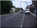
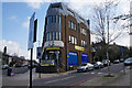
6

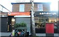
Archway Road
Looking towards the summit of the climb from East Finchley. At the top is the junction with Muswell Hill Road. The road on the right is Bishops Road. Topps Tiles, occupying the modern building on the corner are having a 1/2 price sale, presumably to move stock in the current economic downturn.
Image: © Martin Addison
Taken: 22 May 2009
0.03 miles
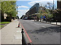
8
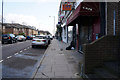
Highgate Police Station
This modern police station closed in 1998 and is currently home to the Haringey Child Abuse Investigation Team. There is a campaign to get it reopened as the community police officers have no premises in the area.
Image: © Martin Addison
Taken: 22 May 2009
0.04 miles
9
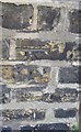
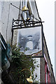
Ordnance Survey Cut Mark
This OS cut mark can be found on the wall post of No17 Bloomfield Road which is on the east side of Bishops Road. It marks a point 108.857m above mean sea level.
Image: © Adrian Dust
Taken: 9 Aug 2016
0.04 miles