IMAGES TAKEN NEAR TO
Yeatman Road, LONDON, N6 4DT
Introduction
This page details the photographs taken nearby to Yeatman Road, N6 4DT by members of the Geograph project.
The Geograph project started in 2005 with the aim of publishing, organising and preserving representative images for every square kilometre of Great Britain, Ireland and the Isle of Man.

There are currently over 7.5m images from over14,400 individuals and you can help contribute to the project by visiting https://www.geograph.org.uk
Image Map
Images are licensed for reuse under creativecommons.org/licenses/by-sa/2.0
Notes
- Clicking on the map will re-center to the selected point.
- The higher the marker number, the further away the image location is from the centre of the postcode.
Image Listing (152 Images Found)
Images are licensed for reuse under creativecommons.org/licenses/by-sa/2.0
Image
Details
Distance
4
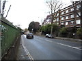
Villa, View Road
Grange View, a new villa at the junction of Grange Road and designed by Harrison Verma, comes with a price tag of almost £9m http://freshome.com/2009/03/13/the-view-road-villa-extravagant-design-wrapped-up-in-lavish-delights/ .
Image: © Derek Harper
Taken: 12 Jun 2010
0.06 miles
8
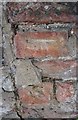
Ordnance Survey Cut Mark
This OS cut mark can be found on the wall of Highcroft on the NE side of North Hill. It marks a point 106.594m above mean sea level.
Image: © Adrian Dust
Taken: 9 Aug 2016
0.07 miles