IMAGES TAKEN NEAR TO
Park View, Collins Road, LONDON, N5 2UE
Introduction
This page details the photographs taken nearby to Park View, Collins Road, N5 2UE by members of the Geograph project.
The Geograph project started in 2005 with the aim of publishing, organising and preserving representative images for every square kilometre of Great Britain, Ireland and the Isle of Man.

There are currently over 7.5m images from over14,400 individuals and you can help contribute to the project by visiting https://www.geograph.org.uk
Image Map
Images are licensed for reuse under creativecommons.org/licenses/by-sa/2.0
Notes
- Clicking on the map will re-center to the selected point.
- The higher the marker number, the further away the image location is from the centre of the postcode.
Image Listing (98 Images Found)
Images are licensed for reuse under creativecommons.org/licenses/by-sa/2.0
Image
Details
Distance
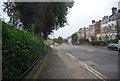
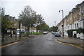
4
The northern end of Petherton Road, N5
Where it meets Green Lanes. The wide central reservation marks the former course of the New River http://en.wikipedia.org/wiki/New_River_(England).
Image: © Mike Quinn
Taken: 11 Mar 2015
0.09 miles
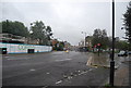
10
The Methodist Church, Green Lanes, N16 (2)
Image: © Mike Quinn
Taken: 11 Mar 2015
0.10 miles