IMAGES TAKEN NEAR TO
Highbury Quadrant, LONDON, N5 2UA
Introduction
This page details the photographs taken nearby to Highbury Quadrant, N5 2UA by members of the Geograph project.
The Geograph project started in 2005 with the aim of publishing, organising and preserving representative images for every square kilometre of Great Britain, Ireland and the Isle of Man.

There are currently over 7.5m images from over14,400 individuals and you can help contribute to the project by visiting https://www.geograph.org.uk
Image Map
Images are licensed for reuse under creativecommons.org/licenses/by-sa/2.0
Notes
- Clicking on the map will re-center to the selected point.
- The higher the marker number, the further away the image location is from the centre of the postcode.
Image Listing (111 Images Found)
Images are licensed for reuse under creativecommons.org/licenses/by-sa/2.0
Image
Details
Distance
1
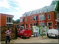
Highbury New Park, N5 (2)
Shows the location of Image
Image: © Mike Quinn
Taken: 26 Jun 2008
0.08 miles
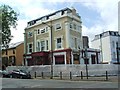
2
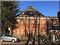
Highbury Quadrant
Congregational church
Image: © Brian Whittle
Taken: 15 Feb 2019
0.08 miles
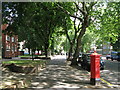
3
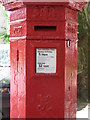
Penfold postbox, Highbury New Park, N5 - royal cipher and crest
See Image
Image: © Mike Quinn
Taken: 26 Jun 2008
0.09 miles
4
Highbury New Park, N5
Shows the location of Image
Image: © Mike Quinn
Taken: 26 Jun 2008
0.09 miles
5
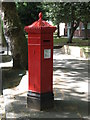
Penfold postbox, Highbury New Park, N5
Image: © Mike Quinn
Taken: 26 Jun 2008
0.09 miles
6
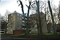
Block of flats on Green Lanes, Highbury
Image: © David Howard
Taken: 2 Dec 2019
0.09 miles
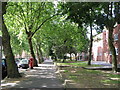
7
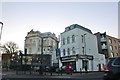
Shops on Green Lanes, Highbury
This is just across the border between N4 and N5
Image: © David Howard
Taken: 2 Dec 2019
0.11 miles