IMAGES TAKEN NEAR TO
Highbury Quadrant, LONDON, N5 2TE
Introduction
This page details the photographs taken nearby to Highbury Quadrant, N5 2TE by members of the Geograph project.
The Geograph project started in 2005 with the aim of publishing, organising and preserving representative images for every square kilometre of Great Britain, Ireland and the Isle of Man.

There are currently over 7.5m images from over14,400 individuals and you can help contribute to the project by visiting https://www.geograph.org.uk
Image Map
Images are licensed for reuse under creativecommons.org/licenses/by-sa/2.0
Notes
- Clicking on the map will re-center to the selected point.
- The higher the marker number, the further away the image location is from the centre of the postcode.
Image Listing (94 Images Found)
Images are licensed for reuse under creativecommons.org/licenses/by-sa/2.0
Image
Details
Distance
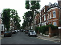
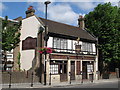
1
Highbury Quadrant
Congregational church
Image: © Brian Whittle
Taken: 15 Feb 2019
0.03 miles
2
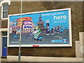
Advertisement for the London bicycle hire scheme, Conewood Street, London N5
Image: © Jim Osley
Taken: 7 Aug 2010
0.09 miles

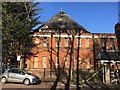
5
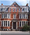
Entrance, former police station, Blackstock Road
Built 1903 this is one of many in the London area by the Metropolitan Police architect John Dixon Butler.
Image: © Jim Osley
Taken: 26 Jul 2014
0.09 miles
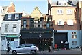
7
The Bank of Friendship
At the southern end of Blackstock Road, N5.
Image: © Mike Quinn
Taken: 26 Jun 2008
0.10 miles
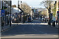
8
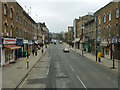
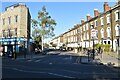
Blackstock Road, N5
From a southbound route 4 bus.
Image: © Robin Webster
Taken: 29 Jan 2011
0.10 miles