IMAGES TAKEN NEAR TO
Beresford Road, LONDON, N5 2HT
Introduction
This page details the photographs taken nearby to Beresford Road, N5 2HT by members of the Geograph project.
The Geograph project started in 2005 with the aim of publishing, organising and preserving representative images for every square kilometre of Great Britain, Ireland and the Isle of Man.

There are currently over 7.5m images from over14,400 individuals and you can help contribute to the project by visiting https://www.geograph.org.uk
Image Map
Images are licensed for reuse under creativecommons.org/licenses/by-sa/2.0
Notes
- Clicking on the map will re-center to the selected point.
- The higher the marker number, the further away the image location is from the centre of the postcode.
Image Listing (209 Images Found)
Images are licensed for reuse under creativecommons.org/licenses/by-sa/2.0
Image
Details
Distance
2
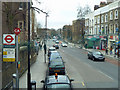
Beresford Road bus stop
The road ahead is Newington Green Road, A105. The stop is named after a right turn nearly opposite the stop.
Image: © Robin Webster
Taken: 15 Jan 2011
0.02 miles
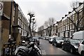
3
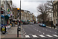
Newington Green Road
Seen from the junction with Grosvenor Avenue.
Image: © Martin Addison
Taken: 19 Feb 2014
0.02 miles
4
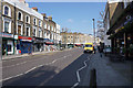
Newington Green Road
A focus of shops in a large residential area.
Image: © Bill Boaden
Taken: 17 Mar 2016
0.02 miles
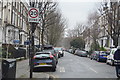
5
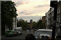
View along Newington Green Road
Looking south-southwest.
Image: © Robert Lamb
Taken: 14 Apr 2022
0.02 miles
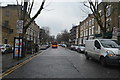
7
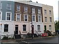
Terrace of houses on Newington Green Road
Image: © David Martin
Taken: 8 May 2014
0.04 miles