IMAGES TAKEN NEAR TO
Highbury Estate, LONDON, N5 2DE
Introduction
This page details the photographs taken nearby to Highbury Estate, N5 2DE by members of the Geograph project.
The Geograph project started in 2005 with the aim of publishing, organising and preserving representative images for every square kilometre of Great Britain, Ireland and the Isle of Man.

There are currently over 7.5m images from over14,400 individuals and you can help contribute to the project by visiting https://www.geograph.org.uk
Image Map
Images are licensed for reuse under creativecommons.org/licenses/by-sa/2.0
Notes
- Clicking on the map will re-center to the selected point.
- The higher the marker number, the further away the image location is from the centre of the postcode.
Image Listing (159 Images Found)
Images are licensed for reuse under creativecommons.org/licenses/by-sa/2.0
Image
Details
Distance
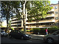
1

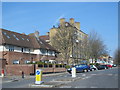
Highbury Estate
Seen from Grosvenor Avenue, the block on the right is Elmfield House.
Image: © Stephen McKay
Taken: 1 Jul 2008
0.03 miles
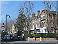
2
Flats on Highbury New Park
This is a typical council block from the 1930s-40s with outside corridors to each flat. The curved balconies appear art deco while the windows may have been replaced but look more from the 50s or so.
Image: © David Howard
Taken: 13 Jun 2014
0.05 miles
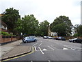
3
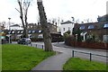
Seaforth Crescent
Walking through to Seaforth Crescent from Aberdeen Park.
Image: © DS Pugh
Taken: 5 Apr 2016
0.06 miles
4
Highbury, Pondfield House
The north angle of Pondfield House carries a cut bench mark. See http://www.geograph.org.uk/photo/5612526 for a close-up and http://www.bench-marks.org.uk/bm90738 for details.
Image: © Brian Westlake
Taken: 6 May 2014
0.06 miles
5
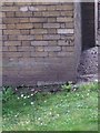
Cut Mark: Highbury, Pondfield House
The north angle of Pondfield House carries a cut bench mark. See http://www.geograph.org.uk/photo/5611138 for a wider view and http://www.bench-marks.org.uk/bm90738 for details.
Image: © Brian Westlake
Taken: 6 May 2014
0.06 miles
6

Spring Gardens estate on Grosvenor Avenue
Part of a large Islington council estate
Image: © David Howard
Taken: 13 Jun 2014
0.07 miles
7
Petherton Road, N5
The west side, north of Grosvenor Avenue. The road is on the line of the former course of the New River http://en.wikipedia.org/wiki/New_River_(England) between St. Paul's Road and Beresford Road.
Image: © Mike Quinn
Taken: 11 Mar 2015
0.07 miles
10
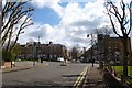
Approaching Petherton Roundabout
Approaching the roundabout and Petherton Road from Seaforth Crescent.
Image: © DS Pugh
Taken: 5 Apr 2016
0.08 miles