1
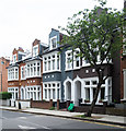
Highbury Crescent
Attractive old houses overlooking Highbury Fields across the road.
Image: © Des Blenkinsopp
Taken: 24 Jul 2016
0.03 miles
2
Highbury Crescent
A jogger makes her way around the edge of Highbury Fields on a cold but sunny winter's day.
Image: © Stephen McKay
Taken: 1 Feb 2012
0.04 miles
3
Don't feed the rats
It is said that in London you are never more than a few feet from a rat, although the animals are seldom seen by the public. Islington Council is all too aware of the problem, however, and is here imploring people not to feed squirrels and pigeons because it provides food for rats as well. The notice is posted at the beginning of Queen's Walk which crosses Highbury Fields from Highbury Crescent.
Image: © Stephen McKay
Taken: 12 Oct 2009
0.04 miles
4
The edge of Highbury Fields
There used to be an old stone-covered spring here which in the 15th century supplied water via a series of lead conduits as far as Moorgate. This gave Highbury Fields its earlier name of Conduit Field. In the 19th century, the whole area around what is now Highbury Fields consisted of open fields and dairy pasture. The fields supplied milk to the city and they were also a favourite place for Londoners to visit and taste warm milk straight from the cow. The fields were acquired by the Metropolitan Board of Works from the descendants of John Dawes who was a wealthy stockbroker and lived at Highbury Manor House. They were declared open to the public on 24th December 1885.
In this photograph, Highbury Crescent is to the right.
Image: © Marathon
Taken: 10 Dec 2014
0.05 miles
5
Melgund Road, Islington
An unusual name.There is a Melgund Castle in County Angus, Scotland, but whether that's relevant here I don't know.
Image: © Des Blenkinsopp
Taken: 24 Jul 2016
0.07 miles
6
Islington Central Library
Image: © Sarah Charlesworth
Taken: 30 Nov 2010
0.07 miles
7
Mid-19th century terraced houses, Fieldway Crescent
Image: © Jim Osley
Taken: 25 May 2018
0.08 miles
8
Islington Central Library, Holloway Road, London N7
Dated 1906 on the foundation stone and elsewhere, altered and enlarged to Fieldway Crescent front in 1973-6. Architect: Henry T. Hare. The principal front of Hare's building faces Holloway Road, and is faced in Portland stone,
and there is a 1906 wing in Fieldway Crescent of red brick set in English bond with stone dressings.
Image: © Jim Osley
Taken: 11 Mar 2010
0.09 miles
9
Cut Mark: Highbury, Highbury Roundhouse
Cut bench mark on the wall of a substation incorporated into the building. See http://www.geograph.org.uk/photo/5612529 for a wider view and http://www.bench-marks.org.uk/bm90740 for details.
Image: © Brian Westlake
Taken: 6 May 2014
0.09 miles
10
Highbury, Highbury Roundhouse
Cut bench mark on the wall of a substation incorporated into the building. See http://www.geograph.org.uk/photo/5612528 for a closer view and http://www.bench-marks.org.uk/bm90740 for details.
Image: © Brian Westlake
Taken: 6 May 2014
0.09 miles


