IMAGES TAKEN NEAR TO
Arvon Road, LONDON, N5 1PL
Introduction
This page details the photographs taken nearby to Arvon Road, N5 1PL by members of the Geograph project.
The Geograph project started in 2005 with the aim of publishing, organising and preserving representative images for every square kilometre of Great Britain, Ireland and the Isle of Man.

There are currently over 7.5m images from over14,400 individuals and you can help contribute to the project by visiting https://www.geograph.org.uk
Image Map
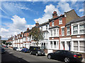
Images are licensed for reuse under creativecommons.org/licenses/by-sa/2.0
Notes
- Clicking on the map will re-center to the selected point.
- The higher the marker number, the further away the image location is from the centre of the postcode.
Image Listing (192 Images Found)
Images are licensed for reuse under creativecommons.org/licenses/by-sa/2.0
Image
Details
Distance
1
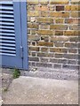
Cut Mark: Highbury, Highbury Roundhouse
Cut bench mark on the wall of a substation incorporated into the building. See http://www.geograph.org.uk/photo/5612529 for a wider view and http://www.bench-marks.org.uk/bm90740 for details.
Image: © Brian Westlake
Taken: 6 May 2014
0.02 miles
2
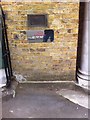
Highbury, Highbury Roundhouse
Cut bench mark on the wall of a substation incorporated into the building. See http://www.geograph.org.uk/photo/5612528 for a closer view and http://www.bench-marks.org.uk/bm90740 for details.
Image: © Brian Westlake
Taken: 6 May 2014
0.02 miles
4
Cut Mark: Highbury, 71 Ronalds Road
Cut bench mark to the left of the frontage of Highbury Crescent Rooms in Ronalds Road. See http://www.geograph.org.uk/photo/5613014 for a wider view and http://www.bench-marks.org.uk/bm90736 for details.
Image: © Brian Westlake
Taken: 6 May 2014
0.05 miles
5
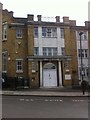
Highbury Assembly Rooms
There is a cut bench mark to the left of the frontage of Highbury Crescent Rooms in Ronalds Road. See http://www.geograph.org.uk/photo/5613009 for a closer view and http://www.bench-marks.org.uk/bm90736 for details.
Image: © Brian Westlake
Taken: 6 May 2014
0.05 miles
6
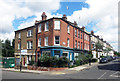
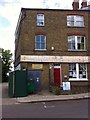
Old shop on the corner, Battledean Road
Now somebody's house.
Image: © Des Blenkinsopp
Taken: 24 Jul 2016
0.06 miles
7
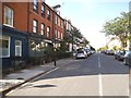
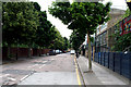
Battledean Road, Highbury
Three converted shops are on the left
Image: © David Howard
Taken: 13 Jun 2014
0.07 miles
8
Flats and offices on Drayton Park, Highbury
Image: © David Howard
Taken: 7 Nov 2021
0.08 miles
9
Melgund Road, Islington
An unusual name.There is a Melgund Castle in County Angus, Scotland, but whether that's relevant here I don't know.
Image: © Des Blenkinsopp
Taken: 24 Jul 2016
0.08 miles
10
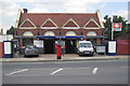
Drayton Park railway station
Drayton Park railway station is on the Network Rail Northern City Line which carries First Capital Connect services between Moorgate and Welwyn Garden City or Hertford via Finsbury Park. It has had a chequered ownership, being opened by the Great Northern & City Railway in 1904, becoming part of the Metropolitan Railway in 1913, being transferred to the Northern Line in 1933, and becoming part of the British Rail network in 1975. For comparison there is a photo of the station at the end of its Metropolitan Railway days in 1933 in the London Transport Museum photographic archive here http://photos.ltmcollection.org/images/max/82/9855682.jpg
Image: © Nigel Cox
Taken: 31 Jul 2007
0.09 miles