IMAGES TAKEN NEAR TO
Crouch Hill, LONDON, N4 4SB
Introduction
This page details the photographs taken nearby to Crouch Hill, N4 4SB by members of the Geograph project.
The Geograph project started in 2005 with the aim of publishing, organising and preserving representative images for every square kilometre of Great Britain, Ireland and the Isle of Man.

There are currently over 7.5m images from over14,400 individuals and you can help contribute to the project by visiting https://www.geograph.org.uk
Image Map
Images are licensed for reuse under creativecommons.org/licenses/by-sa/2.0
Notes
- Clicking on the map will re-center to the selected point.
- The higher the marker number, the further away the image location is from the centre of the postcode.
Image Listing (231 Images Found)
Images are licensed for reuse under creativecommons.org/licenses/by-sa/2.0
Image
Details
Distance
1
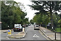
Warltersville Road looking towards Crouch Hill
Image: © David Howard
Taken: 17 Oct 2013
0.01 miles
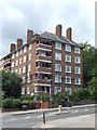
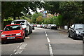
4
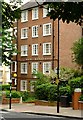
Coleman Mansions, near Crouch End
London Borough of Islington block of flats built in 1937 (Ref:http://www.british-history.ac.uk/vch/middx/vol8/pp29-37 )
Image: © Jim Osley
Taken: 11 Jun 2016
0.02 miles
6
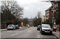
Crouch Hill
A view from the summit looking towards Finsbury Park. On the extreme left and right of the photo are the parapets of the bridge carrying the road over the Parkland Walk - the old Finsbury Park to Alexandra Palace railway line. The white structure just below the horizon is The Emirates Stadium, home of Arsenal Football Club. On the horizon Heron Tower, The Gherkin and Tower 42 are visible along with other City of London office blocks.
Image: © Martin Addison
Taken: 28 Jan 2011
0.04 miles
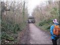
8
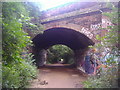
Tunnel under Mount View Road
You can walk from Muswell Hill to Finsbury Park and barely cross a road using the old railway.
Image: © David Howard
Taken: 5 Jul 2012
0.05 miles
9
Crouch End: Former railway line
This is the trackbed of the former Great Northern Railway line from Finsbury Park to Alexandra Palace via Highgate, as viewed looking west under the skewed Mount View Road bridge. The track was lifted in 1972. The trackbed is now a public footpath called Parkland Walk and the whole of the former railway property is a Local Nature Reserve.
Image: © Nigel Cox
Taken: 20 Jun 2007
0.05 miles
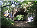
10
View along Parkland Walk, looking west
We see the important overbridge carrying the busy Crouch Hill, part of the A1201. Far below us rumbles LT's Northern Line on its way to East Finchley - if plans had come to fruition, there would have been a surface branch of the Northern Line here also.
Image: © Dr Neil Clifton
Taken: 7 Jan 2012
0.05 miles