IMAGES TAKEN NEAR TO
Dagmar Road, LONDON, N4 4NY
Introduction
This page details the photographs taken nearby to Dagmar Road, N4 4NY by members of the Geograph project.
The Geograph project started in 2005 with the aim of publishing, organising and preserving representative images for every square kilometre of Great Britain, Ireland and the Isle of Man.

There are currently over 7.5m images from over14,400 individuals and you can help contribute to the project by visiting https://www.geograph.org.uk
Image Map
Images are licensed for reuse under creativecommons.org/licenses/by-sa/2.0
Notes
- Clicking on the map will re-center to the selected point.
- The higher the marker number, the further away the image location is from the centre of the postcode.
Image Listing (135 Images Found)
Images are licensed for reuse under creativecommons.org/licenses/by-sa/2.0
Image
Details
Distance
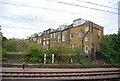
1
Colourful buildings by the East Coast Main Line
Image: © N Chadwick
Taken: 28 May 2014
0.07 miles
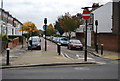
2
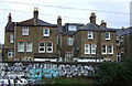
Houses on Beatrice Road
Backing on to the East Coast Main Line.
Image: © JThomas
Taken: 13 Apr 2019
0.07 miles
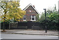
3

Alroy Road HDC building
Where Alroy Road gives way to Wightman Road the now nondescript and onetime Hornsey District Council building backs onto the main Kings Cross railway line. The central archway gives the year of construction as 1902. Now a car repair shop.
Image: © John Kingdon
Taken: 20 Apr 2018
0.07 miles