IMAGES TAKEN NEAR TO
Carlisle Road, LONDON, N4 4NA
Introduction
This page details the photographs taken nearby to Carlisle Road, N4 4NA by members of the Geograph project.
The Geograph project started in 2005 with the aim of publishing, organising and preserving representative images for every square kilometre of Great Britain, Ireland and the Isle of Man.

There are currently over 7.5m images from over14,400 individuals and you can help contribute to the project by visiting https://www.geograph.org.uk
Image Map
Images are licensed for reuse under creativecommons.org/licenses/by-sa/2.0
Notes
- Clicking on the map will re-center to the selected point.
- The higher the marker number, the further away the image location is from the centre of the postcode.
Image Listing (112 Images Found)
Images are licensed for reuse under creativecommons.org/licenses/by-sa/2.0
Image
Details
Distance
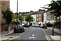
1
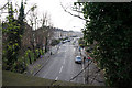
Upper Tollington Park from the Capital Ring path
Image: © Ian S
Taken: 1 Mar 2014
0.05 miles
2
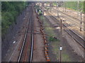
Railway lines north of Finsbury Park station
Heading towards Harringay and beyond
Image: © David Howard
Taken: 5 Jul 2012
0.05 miles
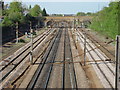
3
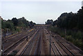
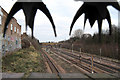
Main Eastern Line at Finsbury Park
This is taken from the footbridge that leads out of Finsbury Park, and looks north up the railway lines that issues from Kings Cross Station
Image: © Chris Heaton
Taken: 7 Sep 2003
0.05 miles
4
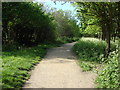
Parkland Walk
A 4.5-mile (7.2 km) linear green walkway along the trackbed of a former Great Northern Railway line.
Image: © Oxyman
Taken: 22 Apr 2009
0.05 miles
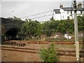
5
East Coast Main Line looking North
Looking north from Image The brick built bridge carries the B150, Upper Tollington Park over the railway line. The bufferstops visible under the arch on the right mark the end of a now rarely used siding.
Image: © Oxyman
Taken: 22 Apr 2009
0.06 miles
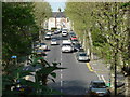
6
Finsbury Park: Florence Road
Looking north.
Image: © Dr Neil Clifton
Taken: 30 Jun 2010
0.06 miles
7
The East Coast main railway line in Finsbury Park area
Image: © Steve Fareham
Taken: 18 Jun 2013
0.06 miles
8
Upper Tollington Park from Parkland Walk
Seen from the top of a former Great Northern Railway bridge that is now part of Parkland Walk
Image: © Oxyman
Taken: 22 Apr 2009
0.07 miles
9
London to York Railway Line
A view of the main London to York railway line as it passes Finsbury Park (on the left). The bridge in the distance carries Upper Tollington Park / Tollington Park across the line. In the foreground the sharp barbs of the anti-climb spinners obscure the sky. They don't seem to be very effective judging by the graffiti on the building to the left.
Image: © Martin Addison
Taken: 28 Jan 2011
0.07 miles
10
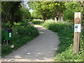
Start of Parkland Walk
A 4.5-mile (7.2 km) linear green walkway along the trackbed of a former Great Northern Railway line.
Image: © Oxyman
Taken: 22 Apr 2009
0.07 miles