IMAGES TAKEN NEAR TO
Scarborough Road, LONDON, N4 4LT
Introduction
This page details the photographs taken nearby to Scarborough Road, N4 4LT by members of the Geograph project.
The Geograph project started in 2005 with the aim of publishing, organising and preserving representative images for every square kilometre of Great Britain, Ireland and the Isle of Man.

There are currently over 7.5m images from over14,400 individuals and you can help contribute to the project by visiting https://www.geograph.org.uk
Image Map
Images are licensed for reuse under creativecommons.org/licenses/by-sa/2.0
Notes
- Clicking on the map will re-center to the selected point.
- The higher the marker number, the further away the image location is from the centre of the postcode.
Image Listing (114 Images Found)
Images are licensed for reuse under creativecommons.org/licenses/by-sa/2.0
Image
Details
Distance
1
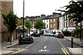
Finsbury Park: Florence Road
Looking north.
Image: © Dr Neil Clifton
Taken: 30 Jun 2010
0.01 miles
2
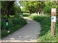
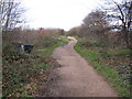
Start of Parkland Walk
A 4.5-mile (7.2 km) linear green walkway along the trackbed of a former Great Northern Railway line.
Image: © Oxyman
Taken: 22 Apr 2009
0.02 miles
4
Parkland Walk
A 4.5-mile (7.2 km) linear green walkway along the trackbed of a former Great Northern Railway line.
Image: © Oxyman
Taken: 22 Apr 2009
0.03 miles
6
Oxford Road
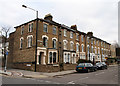
Not to be confused with Oxford Street! This section is a cul-de-sac off Florence Road, leading to the railway line and a footbridge to Finsbury Park. There is another section of Oxford Road on the opposite side of Florence Road, but interestingly the two sections do not form a straight crossroads, suggesting that one was a later addition to the area. The houses are typical terraced designs for the area, having 3 storeys above street level.
Image: © Martin Addison
Taken: 28 Jan 2011
0.04 miles
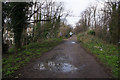
7
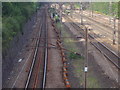
Railway lines north of Finsbury Park station
Heading towards Harringay and beyond
Image: © David Howard
Taken: 5 Jul 2012
0.04 miles
9
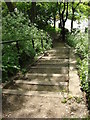
Steps between Parkland Walk and Upper Tollington Park
Image: © Oxyman
Taken: 22 Apr 2009
0.05 miles
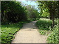
10
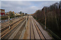
The Parkland Walk, looking south
In the 1930s, the ex-Great Northern Railway line from Edgware to Finsbury Park was planned to become part of London Transport's Northern Line. Electrification would have seen through tube trains running from the GN & City line at Moorgate over a new connection at Finsbury Park, then via Stroud Green, Crouch End, and Highgate High Level to Finchley Central, Mill Hill East, then Mill Hill (The Hale) and Edgware. There would have been an extension from Edgware to Borehamwood and Bushey Heath. A considerable amount of work had been done when Hitler's war intervened and caused the works to be deferred; after the war the plan was first neglected and then abandoned. The trackway from Finsbury Park to Highgate is now used as a footpath and cycle way.
Image: © Dr Neil Clifton
Taken: 7 Jan 2012
0.05 miles