IMAGES TAKEN NEAR TO
Mount Pleasant Villas, LONDON, N4 4HH
Introduction
This page details the photographs taken nearby to Mount Pleasant Villas, N4 4HH by members of the Geograph project.
The Geograph project started in 2005 with the aim of publishing, organising and preserving representative images for every square kilometre of Great Britain, Ireland and the Isle of Man.

There are currently over 7.5m images from over14,400 individuals and you can help contribute to the project by visiting https://www.geograph.org.uk
Image Map
Images are licensed for reuse under creativecommons.org/licenses/by-sa/2.0
Notes
- Clicking on the map will re-center to the selected point.
- The higher the marker number, the further away the image location is from the centre of the postcode.
Image Listing (145 Images Found)
Images are licensed for reuse under creativecommons.org/licenses/by-sa/2.0
Image
Details
Distance
1
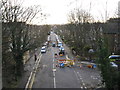
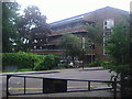
View from Parkland Walk, looking southeast
Taken from the same bridge as Image, we see Mount Pleasant Villas stretching away into the distance. To the right is Blythwood Road.
Image: © Dr Neil Clifton
Taken: 7 Jan 2012
0.01 miles
3
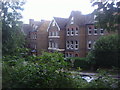
Blythwood Road, Stroud Green
Typical Victorian villas, each with enough room for a large family and its servants
Image: © David Howard
Taken: 5 Jul 2012
0.05 miles
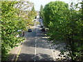
5
Parkland Walk near Crouch End
This section of Parkland Walk is also on the route of the Capital Ring.
Image: © Malc McDonald
Taken: 13 Aug 2023
0.05 miles
6
Allotments by Parkland Walk, Crouch End
Image: © David Howard
Taken: 9 Sep 2014
0.06 miles
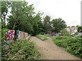
8
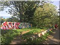
Graffiti at Crouch Hill
The old railway line is now a footpath, the railway bridge a graffiti artists' canvas.
Image: © Alan Hughes
Taken: 13 Oct 2018
0.06 miles
9
Flats on Holly Park from Blythwood Road
Image: © David Howard
Taken: 5 Jul 2012
0.07 miles
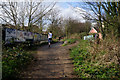
10
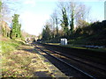
The disused platforms at Crouch Hill station
The Tottenham & Hampstead Junction Railway was planned to run from Tottenham Hale on the Great Eastern Railway to Gospel Oak on the Hampstead Junction section of the London & North Western Railway. It was worked by the North London Railway (NLR) from its opening in 1860, and in 1864 came under NLR control. On 21st July 1868 a new line opened from Tottenham Hale to Highgate Road and this is when Crouch Hill station also opened. It was only in 1887 that an extension to Gospel Oak was achieved but as a passenger exchange not as a junction.
On 9th July 1894, the Tottenham & Forest Gate Railway was opened for through goods and passenger trains with stations at Blackhorse Road, Walthamstow, Leyton, Leytonstone and Wanstead Park opening on the same day. The scheme was completed by a new station at Woodgrange Park, also opened on 9th July 1894 on a pre-existing track which had been laid in 1854.
Up to 1912 the line was a joint railway operated by the Midland Railway and the London, Tilbury & Southend Railway but from 1912 it was solely operated by the Midland. With the opening of the new line the Midland extended some of its South Tottenham trains to East Ham.
The line which now ran between Kentish Town and Barking was considered for closure to passengers in 1963 as part of the Beeching Axe, but it remained open. Even so, it was allowed to fall into a poor state of repair and reliability, and by 1980 had been cut back to an hourly service between Kentish Town and Barking.
The situation began to improve from 1981 when a new link to Gospel Oak was built and the hourly service from Kentish Town to Barking was replaced by the present route from Gospel Oak to Barking with two trains per hour. Now with it being taken over by Transport for London as part of the London Overground network the whole line has a new lease of life and new trains run every 15 minutes between Barking and Gospel Oak.
The platforms were originally built to accommodate longer trains. The unused sections of platform remain beyond a barrier, but are closed and, as can be seen here, are in a poor state of repair. This is the case with many of the stations on the Barking to Gospel Oak Line - another example can be seen at http://www.geograph.org.uk/photo/4015346
The next station in this direction is Harringay Green Lanes.
Image: © Marathon
Taken: 28 Jan 2015
0.07 miles