IMAGES TAKEN NEAR TO
Ferme Park Road, LONDON, N4 4DS
Introduction
This page details the photographs taken nearby to Ferme Park Road, N4 4DS by members of the Geograph project.
The Geograph project started in 2005 with the aim of publishing, organising and preserving representative images for every square kilometre of Great Britain, Ireland and the Isle of Man.

There are currently over 7.5m images from over14,400 individuals and you can help contribute to the project by visiting https://www.geograph.org.uk
Image Map
Images are licensed for reuse under creativecommons.org/licenses/by-sa/2.0
Notes
- Clicking on the map will re-center to the selected point.
- The higher the marker number, the further away the image location is from the centre of the postcode.
Image Listing (93 Images Found)
Images are licensed for reuse under creativecommons.org/licenses/by-sa/2.0
Image
Details
Distance
1
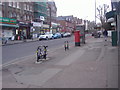
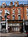
Shops on Ferme Park Road, Stroud Green
This road links Finsbury Park with Hornsey and Crouch End
Image: © David Howard
Taken: 16 Feb 2012
0.00 miles
3
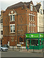
Victorian residence, Stroud Green, London N4
Victorian residence, on the corner of Stapleton Hall Road and Stroud Green Road, London N4, with Venetian Gothic windows and diapered brickwork
Image: © Jim Osley
Taken: 13 Mar 2010
0.01 miles
4
Ferme Park Road and Stapleton Hall Road, N4
Taken from the Parkland Walk Footpath that runs along the disused railway into Finsbury Park.
Image: © Danny P Robinson
Taken: 18 Mar 2007
0.01 miles
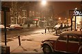
5
The Nicholas Nickleby Pub (Now Closed)
This little 'back street' pub has recently closed and is now advertised as a shop unit to let. It is some years since I last drank there but it was a cosy little pub and its charming frontage will doubtless soon be gone forever.
Image: © John Kingdon
Taken: 26 Sep 2023
0.02 miles
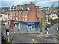
6
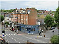
Road junction in Stroud Green, near Finsbury Park
A parade of shops at road junction in the suburbs of north London.
Image: © Malc McDonald
Taken: 13 Aug 2023
0.02 miles
7
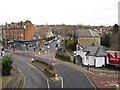
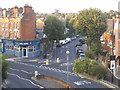
View from Parkland Walk, looking north
In the foreground is Stapleton Hall Road, which continues up right of centre, while the main road bending round to the left is Ferme Park Road. The road coming in from the right is Lancaster Road. This view is taken from the site of Stroud Green station, closed to passengers on 5 July 1954. The station never had goods facilities.
Image: © Dr Neil Clifton
Taken: 7 Jan 2012
0.02 miles
9
Crouch Hill at the junction of Stapleton Hall Road
Image: © David Howard
Taken: 9 Sep 2014
0.03 miles
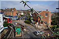
10
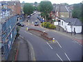
Stapleton Hall Road at the junction of Ferme Park Road
From Parkland Walk
Image: © David Howard
Taken: 5 Jul 2012
0.03 miles